You are here: Home > Network List > UU - University of Utah Regional Network Stations List
> Station CCUT Cedar City, UT, USA > Earthquake Result Viewer
CCUT Cedar City, UT, USA - Earthquake Result Viewer
*The percent match for this event was below the threshold and hence no stack was calculated.
| Earthquake location: |
Near Coast Of Nicaragua |
| Earthquake latitude/longitude: |
11.2/-86.6 |
| Earthquake time(UTC): |
2015/12/31 (365) 10:57:00 GMT |
| Earthquake Depth: |
36 km |
| Earthquake Magnitude: |
5.7 MB |
| Earthquake Catalog/Contributor: |
NEIC PDE/NEIC COMCAT |
|
| Network: |
UU University of Utah Regional Network |
| Station: |
CCUT Cedar City, UT, USA |
| Lat/Lon: |
37.55 N/113.36 W |
| Elevation: |
2127 m |
|
| Distance: |
35.6 deg |
| Az: |
322.081 deg |
| Baz: |
130.646 deg |
| Ray Param: |
$rayparam |
*The percent match for this event was below the threshold and hence was not used in the summary stack. |
|
| Radial Match: |
72.02302 % |
| Radial Bump: |
400 |
| Transverse Match: |
60.72476 % |
| Transverse Bump: |
400 |
| SOD ConfigId: |
7422571 |
| Insert Time: |
2019-04-21 16:18:23.239 +0000 |
| GWidth: |
2.5 |
| Max Bumps: |
400 |
| Tol: |
0.001 |
|
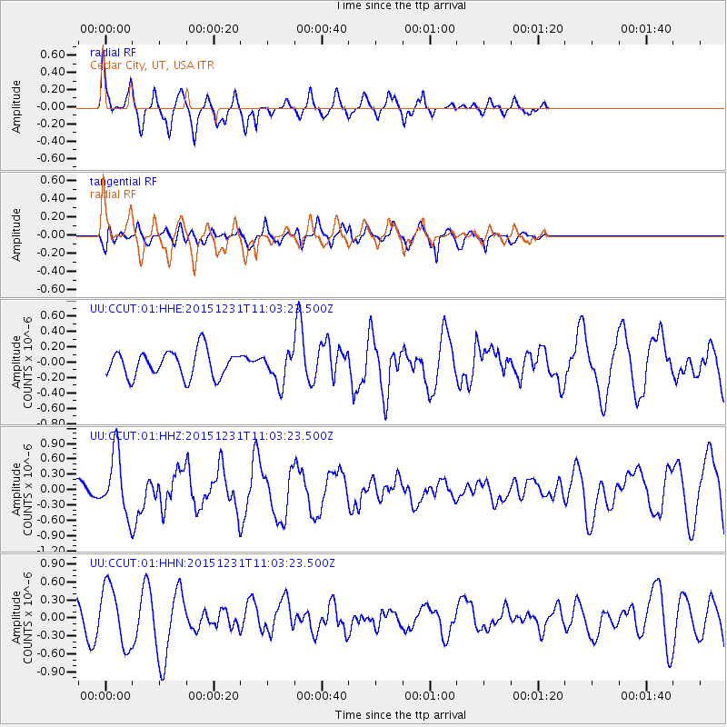
Signal To Noise
| Channel | StoN | STA | LTA |
| UU:CCUT:01:HHZ:20151231T11:03:23.500Z | 5.7825885 | 6.1233294E-7 | 1.0589254E-7 |
| UU:CCUT:01:HHN:20151231T11:03:23.500Z | 1.9190503 | 5.0247087E-7 | 2.6183307E-7 |
| UU:CCUT:01:HHE:20151231T11:03:23.500Z | 1.4361471 | 2.4320784E-7 | 1.6934744E-7 |
| Arrivals |
| Ps | |
| PpPs | |
| PsPs/PpSs | |


