You are here: Home > Network List > IC - New China Digital Seismograph Network Stations List
> Station LSA Tibet, China > Earthquake Result Viewer
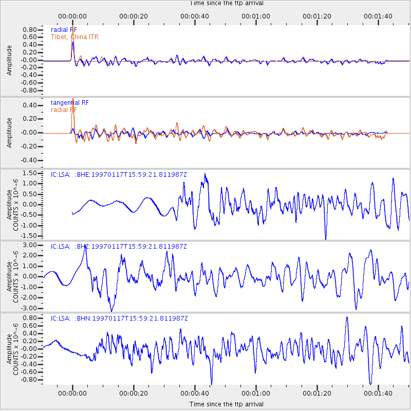
LSA Tibet, China - Earthquake Result Viewer
*The percent match for this event was below the threshold and hence no stack was calculated.
| Earthquake location: |
Ryukyu Islands, Japan |
| Earthquake latitude/longitude: |
28.8/130.0 |
| Earthquake time(UTC): |
1997/01/17 (017) 15:53:13 GMT |
| Earthquake Depth: |
33 km |
| Earthquake Magnitude: |
5.9 MB, 6.3 MS, 6.3 UNKNOWN, 6.2 MW |
| Earthquake Catalog/Contributor: |
WHDF/NEIC |
|
| Network: |
IC New China Digital Seismograph Network |
| Station: |
LSA Tibet, China |
| Lat/Lon: |
29.70 N/91.15 E |
| Elevation: |
3789 m |
|
| Distance: |
33.8 deg |
| Az: |
281.152 deg |
| Baz: |
81.717 deg |
| Ray Param: |
$rayparam |
*The percent match for this event was below the threshold and hence was not used in the summary stack. |
|
| Radial Match: |
76.60063 % |
| Radial Bump: |
400 |
| Transverse Match: |
58.338196 % |
| Transverse Bump: |
400 |
| SOD ConfigId: |
4480 |
| Insert Time: |
2010-03-04 22:59:19.911 +0000 |
| GWidth: |
2.5 |
| Max Bumps: |
400 |
| Tol: |
0.001 |
|
Signal To Noise
| Channel | StoN | STA | LTA |
| IC:LSA: :BHZ:19970117T15:59:21.811987Z | 3.9370213 | 1.3681665E-6 | 3.4751312E-7 |
| IC:LSA: :BHN:19970117T15:59:21.811987Z | 0.9246528 | 1.3219154E-7 | 1.4296343E-7 |
| IC:LSA: :BHE:19970117T15:59:21.811987Z | 2.020135 | 4.095325E-7 | 2.0272532E-7 |
| Arrivals |
| Ps | |
| PpPs | |
| PsPs/PpSs | |


