You are here: Home > Network List > IC - New China Digital Seismograph Network Stations List
> Station LSA Tibet, China > Earthquake Result Viewer
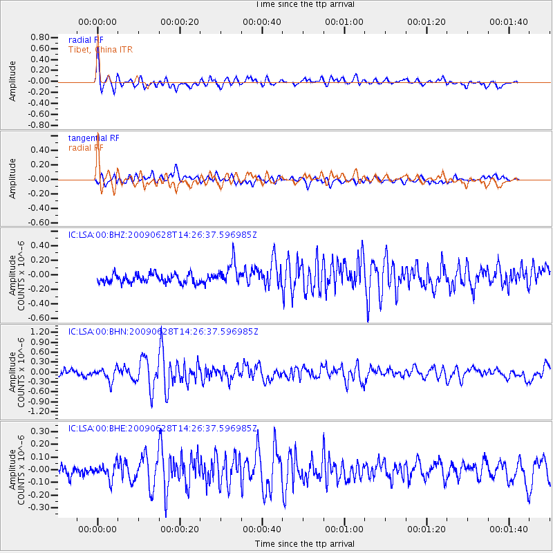
LSA Tibet, China - Earthquake Result Viewer
*The percent match for this event was below the threshold and hence no stack was calculated.
| Earthquake location: |
Minahassa Peninsula, Sulawesi |
| Earthquake latitude/longitude: |
1.4/122.2 |
| Earthquake time(UTC): |
2009/06/28 (179) 14:19:30 GMT |
| Earthquake Depth: |
37 km |
| Earthquake Magnitude: |
5.5 MB, 5.1 MS, 5.7 MW, 5.5 MW |
| Earthquake Catalog/Contributor: |
WHDF/NEIC |
|
| Network: |
IC New China Digital Seismograph Network |
| Station: |
LSA Tibet, China |
| Lat/Lon: |
29.70 N/91.15 E |
| Elevation: |
3789 m |
|
| Distance: |
40.8 deg |
| Az: |
316.621 deg |
| Baz: |
127.892 deg |
| Ray Param: |
$rayparam |
*The percent match for this event was below the threshold and hence was not used in the summary stack. |
|
| Radial Match: |
75.14356 % |
| Radial Bump: |
400 |
| Transverse Match: |
67.12384 % |
| Transverse Bump: |
400 |
| SOD ConfigId: |
2648 |
| Insert Time: |
2010-03-04 22:59:27.955 +0000 |
| GWidth: |
2.5 |
| Max Bumps: |
400 |
| Tol: |
0.001 |
|
Signal To Noise
| Channel | StoN | STA | LTA |
| IC:LSA:00:BHN:20090628T14:26:37.596985Z | 2.7701678 | 2.0350585E-7 | 7.346336E-8 |
| IC:LSA:00:BHE:20090628T14:26:37.596985Z | 2.0107546 | 6.194333E-8 | 3.0806017E-8 |
| IC:LSA:00:BHZ:20090628T14:26:37.596985Z | 2.7410533 | 1.6390524E-7 | 5.979644E-8 |
| Arrivals |
| Ps | |
| PpPs | |
| PsPs/PpSs | |


