You are here: Home > Network List > YT07 - POLENET Stations List
> Station LONW LONW > Earthquake Result Viewer
LONW LONW - Earthquake Result Viewer
| Earthquake location: |
Western Indian-Antarctic Ridge |
| Earthquake latitude/longitude: |
-50.6/139.4 |
| Earthquake time(UTC): |
2016/01/01 (001) 02:00:39 GMT |
| Earthquake Depth: |
10 km |
| Earthquake Magnitude: |
6.3 MWP |
| Earthquake Catalog/Contributor: |
NEIC PDE/NEIC COMCAT |
|
| Network: |
YT POLENET |
| Station: |
LONW LONW |
| Lat/Lon: |
81.35 S/152.74 E |
| Elevation: |
1548 m |
|
| Distance: |
31.2 deg |
| Az: |
176.146 deg |
| Baz: |
343.561 deg |
| Ray Param: |
0.07913445 |
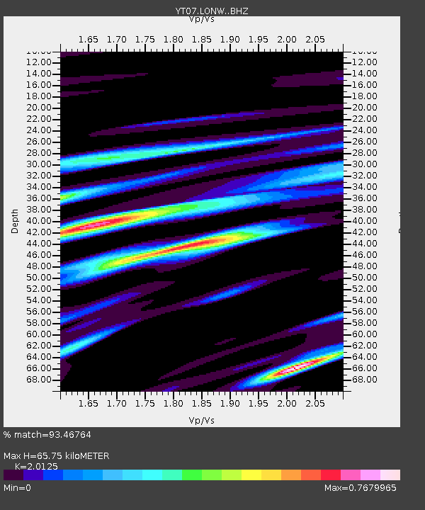
| Estimated Moho Depth: |
65.75 km |
| Estimated Crust Vp/Vs: |
2.01 |
| Assumed Crust Vp: |
6.306 km/s |
| Estimated Crust Vs: |
3.133 km/s |
| Estimated Crust Poisson's Ratio: |
0.34 |
|
| Radial Match: |
93.46764 % |
| Radial Bump: |
300 |
| Transverse Match: |
80.19428 % |
| Transverse Bump: |
400 |
| SOD ConfigId: |
7422571 |
| Insert Time: |
2019-04-21 16:22:26.141 +0000 |
| GWidth: |
2.5 |
| Max Bumps: |
400 |
| Tol: |
0.001 |
|

Signal To Noise
| Channel | StoN | STA | LTA |
| YT:LONW: :BHZ:20160101T02:06:28.649004Z | 12.107508 | 1.1261695E-6 | 9.3014144E-8 |
| YT:LONW: :BHN:20160101T02:06:28.649004Z | 7.530099 | 7.630177E-7 | 1.01329036E-7 |
| YT:LONW: :BHE:20160101T02:06:28.649004Z | 5.5754848 | 4.665623E-7 | 8.368103E-8 |
| Arrivals |
| Ps | 11 SECOND |
| PpPs | 29 SECOND |
| PsPs/PpSs | 41 SECOND |


