You are here: Home > Network List > YT07 - POLENET Stations List
> Station MECK MECK > Earthquake Result Viewer
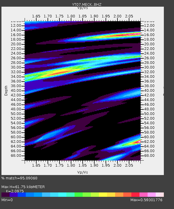
MECK MECK - Earthquake Result Viewer
| Earthquake location: |
Western Indian-Antarctic Ridge |
| Earthquake latitude/longitude: |
-50.6/139.4 |
| Earthquake time(UTC): |
2016/01/01 (001) 02:00:39 GMT |
| Earthquake Depth: |
10 km |
| Earthquake Magnitude: |
6.3 MWP |
| Earthquake Catalog/Contributor: |
NEIC PDE/NEIC COMCAT |
|
| Network: |
YT POLENET |
| Station: |
MECK MECK |
| Lat/Lon: |
75.28 S/72.18 W |
| Elevation: |
1086 m |
|
| Distance: |
52.7 deg |
| Az: |
170.296 deg |
| Baz: |
204.858 deg |
| Ray Param: |
0.06658996 |
| Estimated Moho Depth: |
61.75 km |
| Estimated Crust Vp/Vs: |
2.10 |
| Assumed Crust Vp: |
6.338 km/s |
| Estimated Crust Vs: |
3.022 km/s |
| Estimated Crust Poisson's Ratio: |
0.35 |
|
| Radial Match: |
95.89068 % |
| Radial Bump: |
320 |
| Transverse Match: |
91.65114 % |
| Transverse Bump: |
400 |
| SOD ConfigId: |
7422571 |
| Insert Time: |
2019-04-21 16:22:34.728 +0000 |
| GWidth: |
2.5 |
| Max Bumps: |
400 |
| Tol: |
0.001 |
|

Signal To Noise
| Channel | StoN | STA | LTA |
| YT:MECK: :BHZ:20160101T02:09:23.700029Z | 14.69759 | 1.1273014E-6 | 7.669975E-8 |
| YT:MECK: :BHN:20160101T02:09:23.700029Z | 5.243773 | 5.328898E-7 | 1.0162336E-7 |
| YT:MECK: :BHE:20160101T02:09:23.700029Z | 1.2023476 | 1.2975883E-7 | 1.0792123E-7 |
| Arrivals |
| Ps | 11 SECOND |
| PpPs | 29 SECOND |
| PsPs/PpSs | 40 SECOND |


