You are here: Home > Network List > YT07 - POLENET Stations List
> Station RMBO RMBO > Earthquake Result Viewer
RMBO RMBO - Earthquake Result Viewer
| Earthquake location: |
Western Indian-Antarctic Ridge |
| Earthquake latitude/longitude: |
-50.6/139.4 |
| Earthquake time(UTC): |
2016/01/01 (001) 02:00:39 GMT |
| Earthquake Depth: |
10 km |
| Earthquake Magnitude: |
6.3 MWP |
| Earthquake Catalog/Contributor: |
NEIC PDE/NEIC COMCAT |
|
| Network: |
YT POLENET |
| Station: |
RMBO RMBO |
| Lat/Lon: |
83.87 S/66.40 W |
| Elevation: |
800 m |
|
| Distance: |
45.2 deg |
| Az: |
176.217 deg |
| Baz: |
203.046 deg |
| Ray Param: |
0.071413465 |
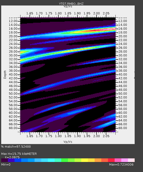
| Estimated Moho Depth: |
15.75 km |
| Estimated Crust Vp/Vs: |
2.10 |
| Assumed Crust Vp: |
6.356 km/s |
| Estimated Crust Vs: |
3.03 km/s |
| Estimated Crust Poisson's Ratio: |
0.35 |
|
| Radial Match: |
97.52488 % |
| Radial Bump: |
315 |
| Transverse Match: |
92.28777 % |
| Transverse Bump: |
400 |
| SOD ConfigId: |
7422571 |
| Insert Time: |
2019-04-21 16:22:38.436 +0000 |
| GWidth: |
2.5 |
| Max Bumps: |
400 |
| Tol: |
0.001 |
|

Signal To Noise
| Channel | StoN | STA | LTA |
| YT:RMBO: :BHZ:20160101T02:08:26.499987Z | 12.166436 | 8.104889E-7 | 6.661679E-8 |
| YT:RMBO: :BHN:20160101T02:08:26.499987Z | 6.449408 | 3.2264407E-7 | 5.002693E-8 |
| YT:RMBO: :BHE:20160101T02:08:26.499987Z | 6.8876443 | 3.3069233E-7 | 4.80124E-8 |
| Arrivals |
| Ps | 2.9 SECOND |
| PpPs | 7.3 SECOND |
| PsPs/PpSs | 10 SECOND |


