You are here: Home > Network List > IC - New China Digital Seismograph Network Stations List
> Station LSA Tibet, China > Earthquake Result Viewer
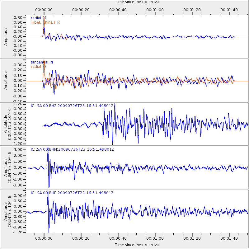
LSA Tibet, China - Earthquake Result Viewer
*The percent match for this event was below the threshold and hence no stack was calculated.
| Earthquake location: |
Southern Sumatra, Indonesia |
| Earthquake latitude/longitude: |
-4.8/102.9 |
| Earthquake time(UTC): |
2009/07/26 (207) 23:10:24 GMT |
| Earthquake Depth: |
47 km |
| Earthquake Magnitude: |
6.0 MB, 5.7 MW, 5.6 MW |
| Earthquake Catalog/Contributor: |
WHDF/NEIC |
|
| Network: |
IC New China Digital Seismograph Network |
| Station: |
LSA Tibet, China |
| Lat/Lon: |
29.70 N/91.15 E |
| Elevation: |
3789 m |
|
| Distance: |
36.1 deg |
| Az: |
342.489 deg |
| Baz: |
159.841 deg |
| Ray Param: |
$rayparam |
*The percent match for this event was below the threshold and hence was not used in the summary stack. |
|
| Radial Match: |
76.44429 % |
| Radial Bump: |
400 |
| Transverse Match: |
76.37706 % |
| Transverse Bump: |
400 |
| SOD ConfigId: |
2648 |
| Insert Time: |
2010-03-04 22:59:55.695 +0000 |
| GWidth: |
2.5 |
| Max Bumps: |
400 |
| Tol: |
0.001 |
|
Signal To Noise
| Channel | StoN | STA | LTA |
| IC:LSA:00:BHN:20090726T23:16:51.49801Z | 16.64318 | 1.2595898E-6 | 7.568204E-8 |
| IC:LSA:00:BHE:20090726T23:16:51.49801Z | 13.196895 | 4.2146E-7 | 3.19363E-8 |
| IC:LSA:00:BHZ:20090726T23:16:51.49801Z | 5.2446346 | 3.7848798E-7 | 7.21667E-8 |
| Arrivals |
| Ps | |
| PpPs | |
| PsPs/PpSs | |


