You are here: Home > Network List > TA - USArray Transportable Network (new EarthScope stations) Stations List
> Station J26L Joseph Creek, AK, USA > Earthquake Result Viewer
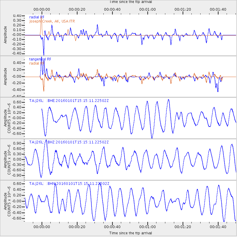
J26L Joseph Creek, AK, USA - Earthquake Result Viewer
*The percent match for this event was below the threshold and hence no stack was calculated.
| Earthquake location: |
Kermadec Islands, New Zealand |
| Earthquake latitude/longitude: |
-29.1/-177.1 |
| Earthquake time(UTC): |
2016/01/01 (001) 15:02:15 GMT |
| Earthquake Depth: |
38 km |
| Earthquake Magnitude: |
5.8 MWB |
| Earthquake Catalog/Contributor: |
NEIC PDE/NEIC COMCAT |
|
| Network: |
TA USArray Transportable Network (new EarthScope stations) |
| Station: |
J26L Joseph Creek, AK, USA |
| Lat/Lon: |
64.50 N/143.56 W |
| Elevation: |
1144 m |
|
| Distance: |
96.9 deg |
| Az: |
13.935 deg |
| Baz: |
209.133 deg |
| Ray Param: |
$rayparam |
*The percent match for this event was below the threshold and hence was not used in the summary stack. |
|
| Radial Match: |
73.206245 % |
| Radial Bump: |
400 |
| Transverse Match: |
57.33355 % |
| Transverse Bump: |
369 |
| SOD ConfigId: |
7422571 |
| Insert Time: |
2019-04-21 16:27:32.848 +0000 |
| GWidth: |
2.5 |
| Max Bumps: |
400 |
| Tol: |
0.001 |
|
Signal To Noise
| Channel | StoN | STA | LTA |
| TA:J26L: :BHZ:20160101T15:15:11.22502Z | 3.616769 | 7.472953E-7 | 2.0661957E-7 |
| TA:J26L: :BHN:20160101T15:15:11.22502Z | 0.5384977 | 1.3048144E-7 | 2.423064E-7 |
| TA:J26L: :BHE:20160101T15:15:11.22502Z | 1.0395093 | 2.8306434E-7 | 2.7230573E-7 |
| Arrivals |
| Ps | |
| PpPs | |
| PsPs/PpSs | |


