You are here: Home > Network List > IC - New China Digital Seismograph Network Stations List
> Station MDJ Mudanjiang, Heilongjiang Province, China > Earthquake Result Viewer
MDJ Mudanjiang, Heilongjiang Province, China - Earthquake Result Viewer
| Earthquake location: |
Banda Sea |
| Earthquake latitude/longitude: |
-7.0/123.4 |
| Earthquake time(UTC): |
2000/08/07 (220) 14:33:55 GMT |
| Earthquake Depth: |
648 km |
| Earthquake Magnitude: |
6.5 MB, 6.5 MW, 6.5 MW |
| Earthquake Catalog/Contributor: |
WHDF/NEIC |
|
| Network: |
IC New China Digital Seismograph Network |
| Station: |
MDJ Mudanjiang, Heilongjiang Province, China |
| Lat/Lon: |
44.62 N/129.59 E |
| Elevation: |
250 m |
|
| Distance: |
51.7 deg |
| Az: |
5.672 deg |
| Baz: |
187.895 deg |
| Ray Param: |
0.06418483 |
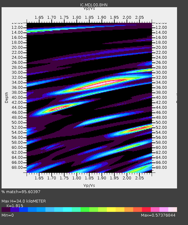
| Estimated Moho Depth: |
34.0 km |
| Estimated Crust Vp/Vs: |
1.91 |
| Assumed Crust Vp: |
6.459 km/s |
| Estimated Crust Vs: |
3.373 km/s |
| Estimated Crust Poisson's Ratio: |
0.31 |
|
| Radial Match: |
95.60397 % |
| Radial Bump: |
305 |
| Transverse Match: |
94.317 % |
| Transverse Bump: |
400 |
| SOD ConfigId: |
3744 |
| Insert Time: |
2010-03-04 23:00:30.277 +0000 |
| GWidth: |
2.5 |
| Max Bumps: |
400 |
| Tol: |
0.001 |
|
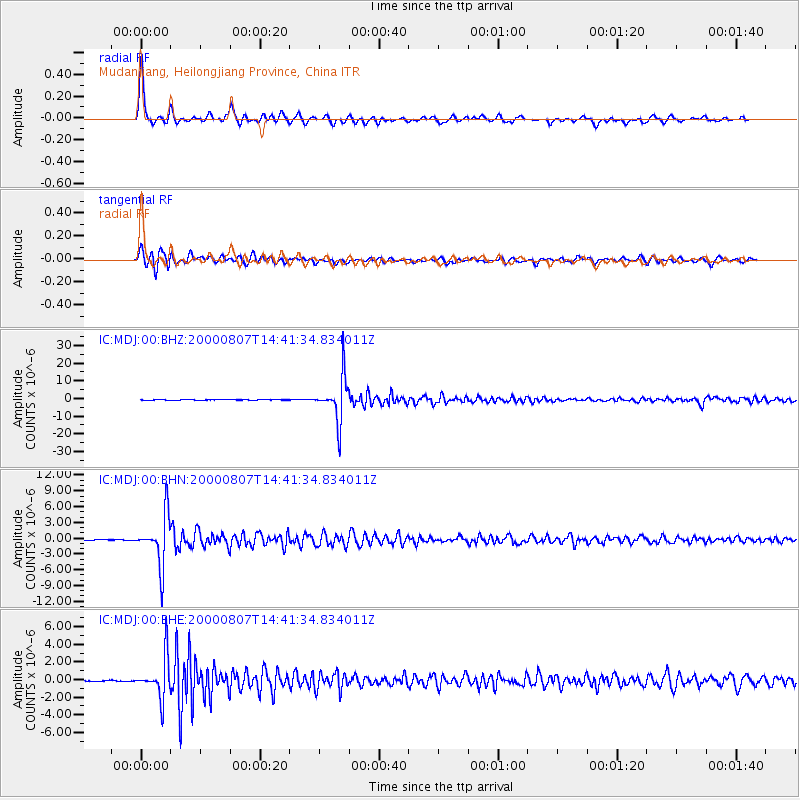
Signal To Noise
| Channel | StoN | STA | LTA |
| IC:MDJ:00:BHN:20000807T14:41:34.834011Z | 86.899864 | 4.680739E-6 | 5.386359E-8 |
| IC:MDJ:00:BHE:20000807T14:41:34.834011Z | 38.60059 | 2.2866154E-6 | 5.9237834E-8 |
| IC:MDJ:00:BHZ:20000807T14:41:34.834011Z | 178.48967 | 1.2462692E-5 | 6.9823045E-8 |
| Arrivals |
| Ps | 5.1 SECOND |
| PpPs | 15 SECOND |
| PsPs/PpSs | 20 SECOND |


