You are here: Home > Network List > IC - New China Digital Seismograph Network Stations List
> Station MDJ Mudanjiang, Heilongjiang Province, China > Earthquake Result Viewer
MDJ Mudanjiang, Heilongjiang Province, China - Earthquake Result Viewer

| Earthquake location: |
Banda Sea |
| Earthquake latitude/longitude: |
-4.3/123.2 |
| Earthquake time(UTC): |
2000/05/14 (135) 20:08:34 GMT |
| Earthquake Depth: |
33 km |
| Earthquake Magnitude: |
5.9 MB, 5.9 MS, 6.3 MW, 6.2 MW |
| Earthquake Catalog/Contributor: |
WHDF/NEIC |
|
| Network: |
IC New China Digital Seismograph Network |
| Station: |
MDJ Mudanjiang, Heilongjiang Province, China |
| Lat/Lon: |
44.62 N/129.59 E |
| Elevation: |
250 m |
|
| Distance: |
49.0 deg |
| Az: |
6.078 deg |
| Baz: |
188.503 deg |
| Ray Param: |
0.068899065 |
| Estimated Moho Depth: |
35.75 km |
| Estimated Crust Vp/Vs: |
1.85 |
| Assumed Crust Vp: |
6.459 km/s |
| Estimated Crust Vs: |
3.496 km/s |
| Estimated Crust Poisson's Ratio: |
0.29 |
|
| Radial Match: |
96.35129 % |
| Radial Bump: |
362 |
| Transverse Match: |
86.99431 % |
| Transverse Bump: |
400 |
| SOD ConfigId: |
3744 |
| Insert Time: |
2010-03-04 23:00:49.060 +0000 |
| GWidth: |
2.5 |
| Max Bumps: |
400 |
| Tol: |
0.001 |
|
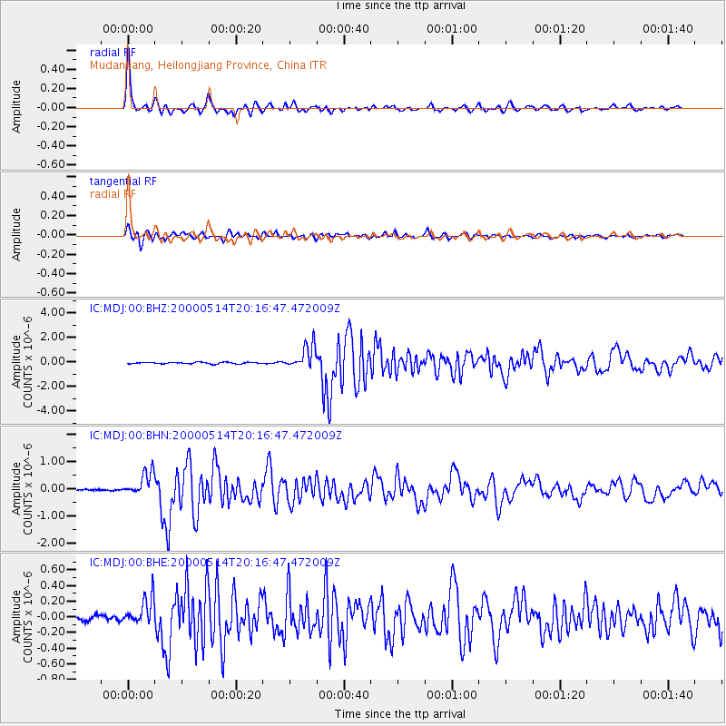
Signal To Noise
| Channel | StoN | STA | LTA |
| IC:MDJ:00:BHN:20000514T20:16:47.472009Z | 10.755841 | 4.3887192E-7 | 4.0803123E-8 |
| IC:MDJ:00:BHE:20000514T20:16:47.472009Z | 4.9826646 | 1.7644938E-7 | 3.5412654E-8 |
| IC:MDJ:00:BHZ:20000514T20:16:47.472009Z | 16.415943 | 9.705086E-7 | 5.9119877E-8 |
| Arrivals |
| Ps | 5.0 SECOND |
| PpPs | 15 SECOND |
| PsPs/PpSs | 20 SECOND |


