You are here: Home > Network List > 8A - AfricaArray - Namibia Stations List
> Station NEPA Namibia > Earthquake Result Viewer
NEPA Namibia - Earthquake Result Viewer
| Earthquake location: |
Myanmar-India Border Region |
| Earthquake latitude/longitude: |
24.8/93.7 |
| Earthquake time(UTC): |
2016/01/03 (003) 23:05:22 GMT |
| Earthquake Depth: |
55 km |
| Earthquake Magnitude: |
6.7 MWW, 6.6 MWB |
| Earthquake Catalog/Contributor: |
NEIC PDE/NEIC COMCAT |
|
| Network: |
8A AfricaArray - Namibia |
| Station: |
NEPA Namibia |
| Lat/Lon: |
17.77 S/18.46 E |
| Elevation: |
1129 m |
|
| Distance: |
84.6 deg |
| Az: |
247.728 deg |
| Baz: |
61.932 deg |
| Ray Param: |
0.04528467 |
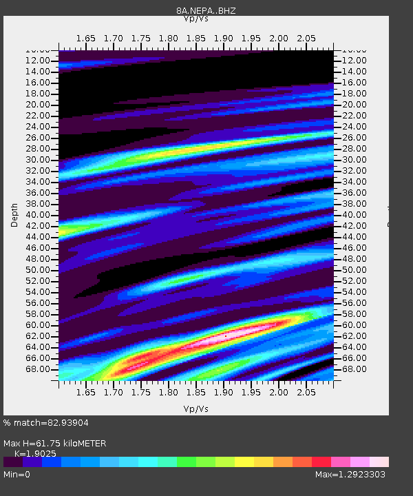
| Estimated Moho Depth: |
61.75 km |
| Estimated Crust Vp/Vs: |
1.90 |
| Assumed Crust Vp: |
6.428 km/s |
| Estimated Crust Vs: |
3.379 km/s |
| Estimated Crust Poisson's Ratio: |
0.31 |
|
| Radial Match: |
82.93904 % |
| Radial Bump: |
400 |
| Transverse Match: |
76.71669 % |
| Transverse Bump: |
400 |
| SOD ConfigId: |
7422571 |
| Insert Time: |
2019-04-21 16:40:30.707 +0000 |
| GWidth: |
2.5 |
| Max Bumps: |
400 |
| Tol: |
0.001 |
|

Signal To Noise
| Channel | StoN | STA | LTA |
| 8A:NEPA: :BHZ:20160103T23:17:18.23498Z | 9.676567 | 1.2032796E-6 | 1.2434984E-7 |
| 8A:NEPA: :BHN:20160103T23:17:18.23498Z | 1.9247661 | 5.0585993E-7 | 2.6281631E-7 |
| 8A:NEPA: :BHE:20160103T23:17:18.23498Z | 1.7837191 | 5.577139E-7 | 3.1266916E-7 |
| Arrivals |
| Ps | 8.9 SECOND |
| PpPs | 27 SECOND |
| PsPs/PpSs | 36 SECOND |


