You are here: Home > Network List > AU - Australian Seismological Centre Stations List
> Station MORW Morawa, Western Australia > Earthquake Result Viewer
MORW Morawa, Western Australia - Earthquake Result Viewer
| Earthquake location: |
Myanmar-India Border Region |
| Earthquake latitude/longitude: |
24.8/93.7 |
| Earthquake time(UTC): |
2016/01/03 (003) 23:05:22 GMT |
| Earthquake Depth: |
55 km |
| Earthquake Magnitude: |
6.7 MWW, 6.6 MWB |
| Earthquake Catalog/Contributor: |
NEIC PDE/NEIC COMCAT |
|
| Network: |
AU Australian Seismological Centre |
| Station: |
MORW Morawa, Western Australia |
| Lat/Lon: |
29.07 S/116.04 E |
| Elevation: |
296 m |
|
| Distance: |
57.8 deg |
| Az: |
156.785 deg |
| Baz: |
335.85 deg |
| Ray Param: |
0.06315847 |
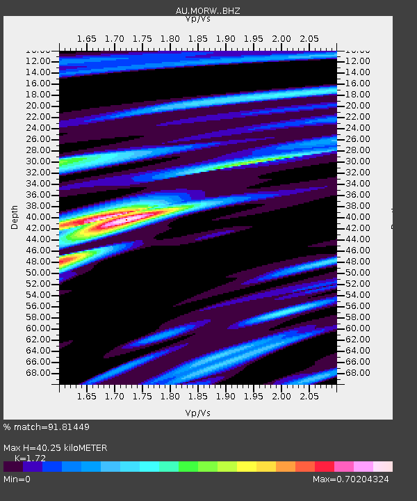
| Estimated Moho Depth: |
40.25 km |
| Estimated Crust Vp/Vs: |
1.72 |
| Assumed Crust Vp: |
6.459 km/s |
| Estimated Crust Vs: |
3.755 km/s |
| Estimated Crust Poisson's Ratio: |
0.24 |
|
| Radial Match: |
91.81449 % |
| Radial Bump: |
360 |
| Transverse Match: |
83.00505 % |
| Transverse Bump: |
400 |
| SOD ConfigId: |
7422571 |
| Insert Time: |
2019-04-21 16:41:53.105 +0000 |
| GWidth: |
2.5 |
| Max Bumps: |
400 |
| Tol: |
0.001 |
|

Signal To Noise
| Channel | StoN | STA | LTA |
| AU:MORW: :BHZ:20160103T23:14:36.643977Z | 13.7293 | 2.734865E-6 | 1.9919916E-7 |
| AU:MORW: :BHN:20160103T23:14:36.643977Z | 6.5361223 | 1.1245172E-6 | 1.7204653E-7 |
| AU:MORW: :BHE:20160103T23:14:36.643977Z | 4.859368 | 6.1054914E-7 | 1.2564374E-7 |
| Arrivals |
| Ps | 4.7 SECOND |
| PpPs | 16 SECOND |
| PsPs/PpSs | 21 SECOND |


