You are here: Home > Network List > AU - Australian Seismological Centre Stations List
> Station WRKA Warrakurna, Western Australia > Earthquake Result Viewer
WRKA Warrakurna, Western Australia - Earthquake Result Viewer
| Earthquake location: |
Myanmar-India Border Region |
| Earthquake latitude/longitude: |
24.8/93.7 |
| Earthquake time(UTC): |
2016/01/03 (003) 23:05:22 GMT |
| Earthquake Depth: |
55 km |
| Earthquake Magnitude: |
6.7 MWW, 6.6 MWB |
| Earthquake Catalog/Contributor: |
NEIC PDE/NEIC COMCAT |
|
| Network: |
AU Australian Seismological Centre |
| Station: |
WRKA Warrakurna, Western Australia |
| Lat/Lon: |
25.04 S/128.30 E |
| Elevation: |
622 m |
|
| Distance: |
59.8 deg |
| Az: |
143.393 deg |
| Baz: |
323.324 deg |
| Ray Param: |
0.061790153 |
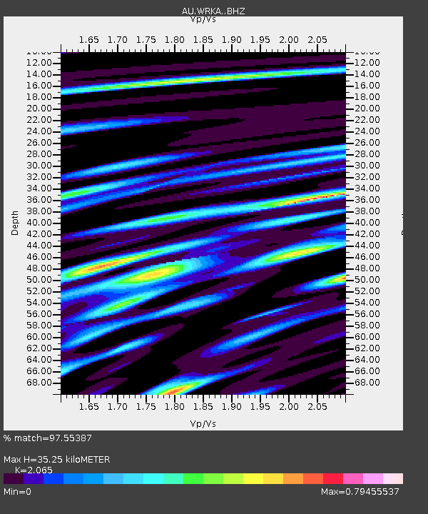
| Estimated Moho Depth: |
35.25 km |
| Estimated Crust Vp/Vs: |
2.07 |
| Assumed Crust Vp: |
6.51 km/s |
| Estimated Crust Vs: |
3.153 km/s |
| Estimated Crust Poisson's Ratio: |
0.35 |
|
| Radial Match: |
97.55387 % |
| Radial Bump: |
400 |
| Transverse Match: |
92.012985 % |
| Transverse Bump: |
400 |
| SOD ConfigId: |
7422571 |
| Insert Time: |
2019-04-21 16:42:00.308 +0000 |
| GWidth: |
2.5 |
| Max Bumps: |
400 |
| Tol: |
0.001 |
|

Signal To Noise
| Channel | StoN | STA | LTA |
| AU:WRKA: :BHZ:20160103T23:14:51.143977Z | 16.882463 | 3.0001438E-6 | 1.777077E-7 |
| AU:WRKA: :BHN:20160103T23:14:51.143977Z | 10.854432 | 1.2201318E-6 | 1.1240863E-7 |
| AU:WRKA: :BHE:20160103T23:14:51.143977Z | 8.355274 | 8.344887E-7 | 9.9875685E-8 |
| Arrivals |
| Ps | 6.0 SECOND |
| PpPs | 16 SECOND |
| PsPs/PpSs | 22 SECOND |


