You are here: Home > Network List > AU - Australian Seismological Centre Stations List
> Station XMI Christmas Island Airport > Earthquake Result Viewer
XMI Christmas Island Airport - Earthquake Result Viewer
| Earthquake location: |
Myanmar-India Border Region |
| Earthquake latitude/longitude: |
24.8/93.7 |
| Earthquake time(UTC): |
2016/01/03 (003) 23:05:22 GMT |
| Earthquake Depth: |
55 km |
| Earthquake Magnitude: |
6.7 MWW, 6.6 MWB |
| Earthquake Catalog/Contributor: |
NEIC PDE/NEIC COMCAT |
|
| Network: |
AU Australian Seismological Centre |
| Station: |
XMI Christmas Island Airport |
| Lat/Lon: |
10.45 S/105.69 E |
| Elevation: |
252 m |
|
| Distance: |
37.0 deg |
| Az: |
160.07 deg |
| Baz: |
341.647 deg |
| Ray Param: |
0.07624008 |
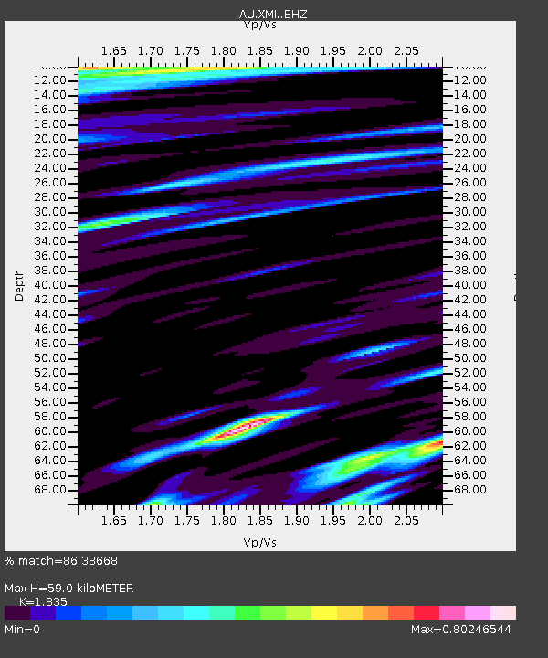
| Estimated Moho Depth: |
59.0 km |
| Estimated Crust Vp/Vs: |
1.84 |
| Assumed Crust Vp: |
4.157 km/s |
| Estimated Crust Vs: |
2.265 km/s |
| Estimated Crust Poisson's Ratio: |
0.29 |
|
| Radial Match: |
86.38668 % |
| Radial Bump: |
400 |
| Transverse Match: |
85.15007 % |
| Transverse Bump: |
400 |
| SOD ConfigId: |
7422571 |
| Insert Time: |
2019-04-21 16:42:00.483 +0000 |
| GWidth: |
2.5 |
| Max Bumps: |
400 |
| Tol: |
0.001 |
|

Signal To Noise
| Channel | StoN | STA | LTA |
| AU:XMI: :BHZ:20160103T23:11:55.693995Z | 10.705203 | 9.570508E-6 | 8.9400527E-7 |
| AU:XMI: :BHN:20160103T23:11:55.693995Z | 3.4991927 | 1.3914143E-6 | 3.9763864E-7 |
| AU:XMI: :BHE:20160103T23:11:55.693995Z | 4.361072 | 2.6096782E-6 | 5.9840295E-7 |
| Arrivals |
| Ps | 12 SECOND |
| PpPs | 39 SECOND |
| PsPs/PpSs | 51 SECOND |


