You are here: Home > Network List > AV - Alaska Volcano Observatory Stations List
> Station AUJA Augustine Junction, Augustine Volcano, Alaska > Earthquake Result Viewer
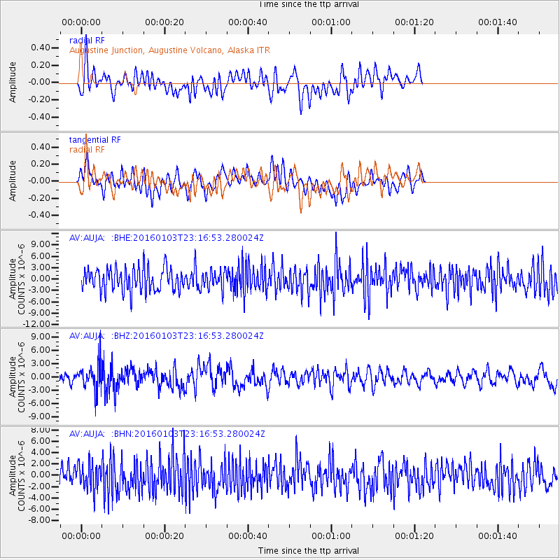
AUJA Augustine Junction, Augustine Volcano, Alaska - Earthquake Result Viewer
*The percent match for this event was below the threshold and hence no stack was calculated.
| Earthquake location: |
Myanmar-India Border Region |
| Earthquake latitude/longitude: |
24.8/93.7 |
| Earthquake time(UTC): |
2016/01/03 (003) 23:05:22 GMT |
| Earthquake Depth: |
55 km |
| Earthquake Magnitude: |
6.7 MWW, 6.6 MWB |
| Earthquake Catalog/Contributor: |
NEIC PDE/NEIC COMCAT |
|
| Network: |
AV Alaska Volcano Observatory |
| Station: |
AUJA Augustine Junction, Augustine Volcano, Alaska |
| Lat/Lon: |
59.34 N/153.42 W |
| Elevation: |
376 m |
|
| Distance: |
79.8 deg |
| Az: |
28.66 deg |
| Baz: |
301.753 deg |
| Ray Param: |
$rayparam |
*The percent match for this event was below the threshold and hence was not used in the summary stack. |
|
| Radial Match: |
50.69599 % |
| Radial Bump: |
400 |
| Transverse Match: |
59.31191 % |
| Transverse Bump: |
400 |
| SOD ConfigId: |
7422571 |
| Insert Time: |
2019-04-21 16:42:03.964 +0000 |
| GWidth: |
2.5 |
| Max Bumps: |
400 |
| Tol: |
0.001 |
|
Signal To Noise
| Channel | StoN | STA | LTA |
| AV:AUJA: :BHZ:20160103T23:16:53.280024Z | 2.464638 | 3.0707656E-6 | 1.2459296E-6 |
| AV:AUJA: :BHN:20160103T23:16:53.280024Z | 1.2311718 | 2.3617301E-6 | 1.9182783E-6 |
| AV:AUJA: :BHE:20160103T23:16:53.280024Z | 0.78172475 | 2.3323053E-6 | 2.9835376E-6 |
| Arrivals |
| Ps | |
| PpPs | |
| PsPs/PpSs | |


