You are here: Home > Network List > CZ - Czech Regional Seismic Network Stations List
> Station DPC Dobruska, Czech Republic > Earthquake Result Viewer
DPC Dobruska, Czech Republic - Earthquake Result Viewer
| Earthquake location: |
Myanmar-India Border Region |
| Earthquake latitude/longitude: |
24.8/93.7 |
| Earthquake time(UTC): |
2016/01/03 (003) 23:05:22 GMT |
| Earthquake Depth: |
55 km |
| Earthquake Magnitude: |
6.7 MWW, 6.6 MWB |
| Earthquake Catalog/Contributor: |
NEIC PDE/NEIC COMCAT |
|
| Network: |
CZ Czech Regional Seismic Network |
| Station: |
DPC Dobruska, Czech Republic |
| Lat/Lon: |
50.36 N/16.41 E |
| Elevation: |
760 m |
|
| Distance: |
63.3 deg |
| Az: |
315.633 deg |
| Baz: |
82.703 deg |
| Ray Param: |
0.059539985 |
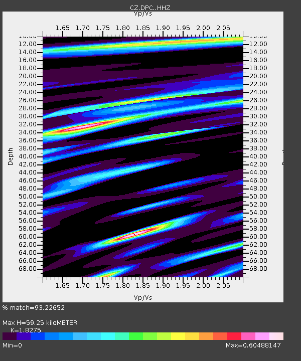
| Estimated Moho Depth: |
59.25 km |
| Estimated Crust Vp/Vs: |
1.83 |
| Assumed Crust Vp: |
6.194 km/s |
| Estimated Crust Vs: |
3.389 km/s |
| Estimated Crust Poisson's Ratio: |
0.29 |
|
| Radial Match: |
93.22652 % |
| Radial Bump: |
256 |
| Transverse Match: |
72.68563 % |
| Transverse Bump: |
387 |
| SOD ConfigId: |
7422571 |
| Insert Time: |
2019-04-21 16:42:40.578 +0000 |
| GWidth: |
2.5 |
| Max Bumps: |
400 |
| Tol: |
0.001 |
|
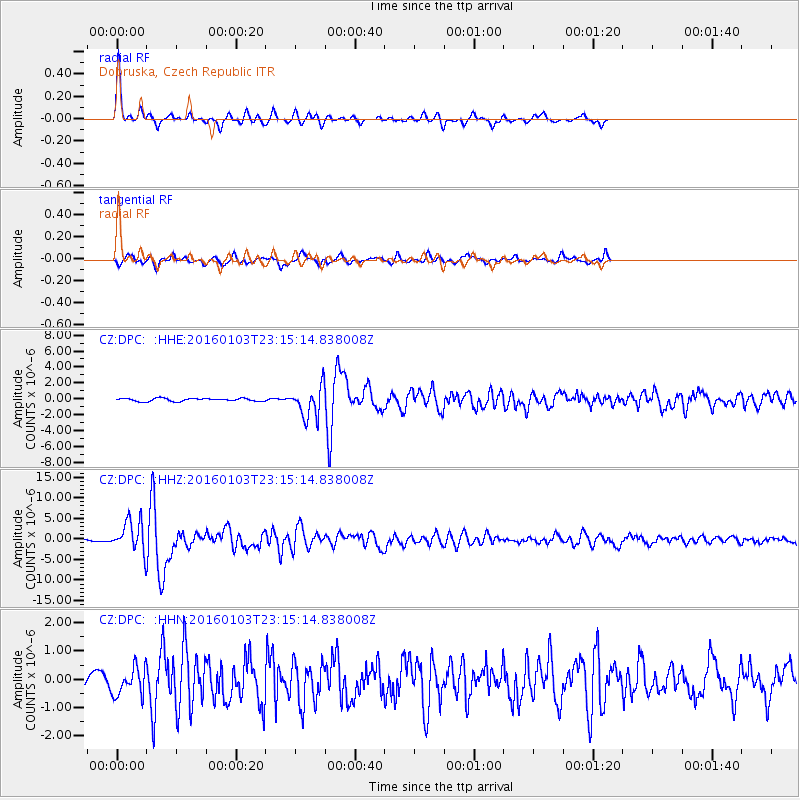
Signal To Noise
| Channel | StoN | STA | LTA |
| CZ:DPC: :HHZ:20160103T23:15:14.838008Z | 12.159127 | 3.7188988E-6 | 3.0585244E-7 |
| CZ:DPC: :HHN:20160103T23:15:14.838008Z | 1.8549829 | 4.852813E-7 | 2.616096E-7 |
| CZ:DPC: :HHE:20160103T23:15:14.838008Z | 9.260915 | 1.7771271E-6 | 1.9189541E-7 |
| Arrivals |
| Ps | 8.2 SECOND |
| PpPs | 26 SECOND |
| PsPs/PpSs | 34 SECOND |


