You are here: Home > Network List > DK - Danish Seismological Network Stations List
> Station BSD BORNHOLM SKOVBRYNET, DENMARK > Earthquake Result Viewer
BSD BORNHOLM SKOVBRYNET, DENMARK - Earthquake Result Viewer
| Earthquake location: |
Myanmar-India Border Region |
| Earthquake latitude/longitude: |
24.8/93.7 |
| Earthquake time(UTC): |
2016/01/03 (003) 23:05:22 GMT |
| Earthquake Depth: |
55 km |
| Earthquake Magnitude: |
6.7 MWW, 6.6 MWB |
| Earthquake Catalog/Contributor: |
NEIC PDE/NEIC COMCAT |
|
| Network: |
DK Danish Seismological Network |
| Station: |
BSD BORNHOLM SKOVBRYNET, DENMARK |
| Lat/Lon: |
55.11 N/14.91 E |
| Elevation: |
88 m |
|
| Distance: |
63.7 deg |
| Az: |
321.04 deg |
| Baz: |
83.93 deg |
| Ray Param: |
0.059311863 |
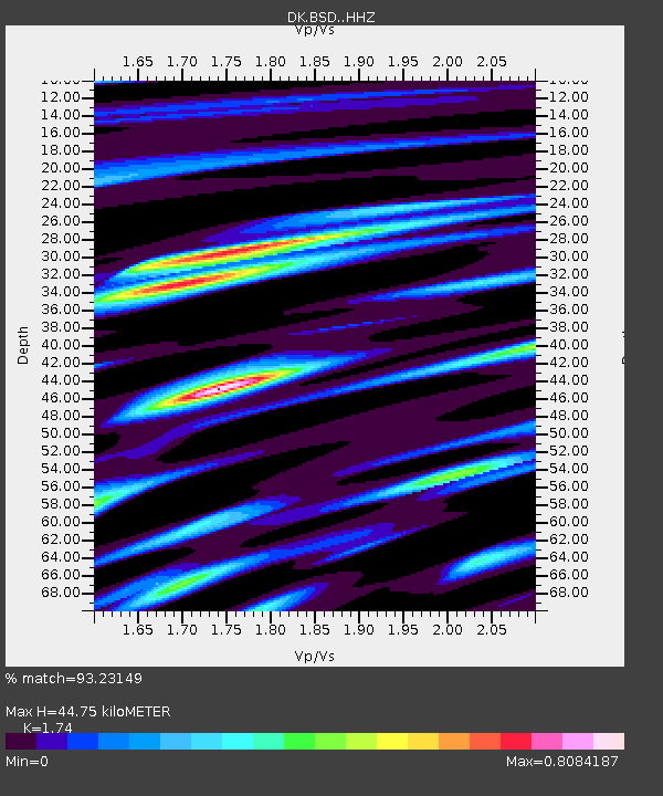
| Estimated Moho Depth: |
44.75 km |
| Estimated Crust Vp/Vs: |
1.74 |
| Assumed Crust Vp: |
6.194 km/s |
| Estimated Crust Vs: |
3.56 km/s |
| Estimated Crust Poisson's Ratio: |
0.25 |
|
| Radial Match: |
93.23149 % |
| Radial Bump: |
222 |
| Transverse Match: |
86.5698 % |
| Transverse Bump: |
311 |
| SOD ConfigId: |
7422571 |
| Insert Time: |
2019-04-21 16:42:44.547 +0000 |
| GWidth: |
2.5 |
| Max Bumps: |
400 |
| Tol: |
0.001 |
|

Signal To Noise
| Channel | StoN | STA | LTA |
| DK:BSD: :HHZ:20160103T23:15:16.754023Z | 12.439762 | 3.65033E-6 | 2.934405E-7 |
| DK:BSD: :HHN:20160103T23:15:16.754023Z | 4.143465 | 1.155022E-6 | 2.787575E-7 |
| DK:BSD: :HHE:20160103T23:15:16.754023Z | 10.267106 | 3.2939859E-6 | 3.2082903E-7 |
| Arrivals |
| Ps | 5.6 SECOND |
| PpPs | 19 SECOND |
| PsPs/PpSs | 25 SECOND |


