You are here: Home > Network List > TA - USArray Transportable Network (new EarthScope stations) Stations List
> Station A36M Sachs Harbour, NT, CAN > Earthquake Result Viewer
A36M Sachs Harbour, NT, CAN - Earthquake Result Viewer
| Earthquake location: |
Myanmar-India Border Region |
| Earthquake latitude/longitude: |
24.8/93.7 |
| Earthquake time(UTC): |
2016/01/03 (003) 23:05:22 GMT |
| Earthquake Depth: |
55 km |
| Earthquake Magnitude: |
6.7 MWW, 6.6 MWB |
| Earthquake Catalog/Contributor: |
NEIC PDE/NEIC COMCAT |
|
| Network: |
TA USArray Transportable Network (new EarthScope stations) |
| Station: |
A36M Sachs Harbour, NT, CAN |
| Lat/Lon: |
71.99 N/125.25 W |
| Elevation: |
32 m |
|
| Distance: |
79.8 deg |
| Az: |
11.45 deg |
| Baz: |
324.567 deg |
| Ray Param: |
0.048605442 |
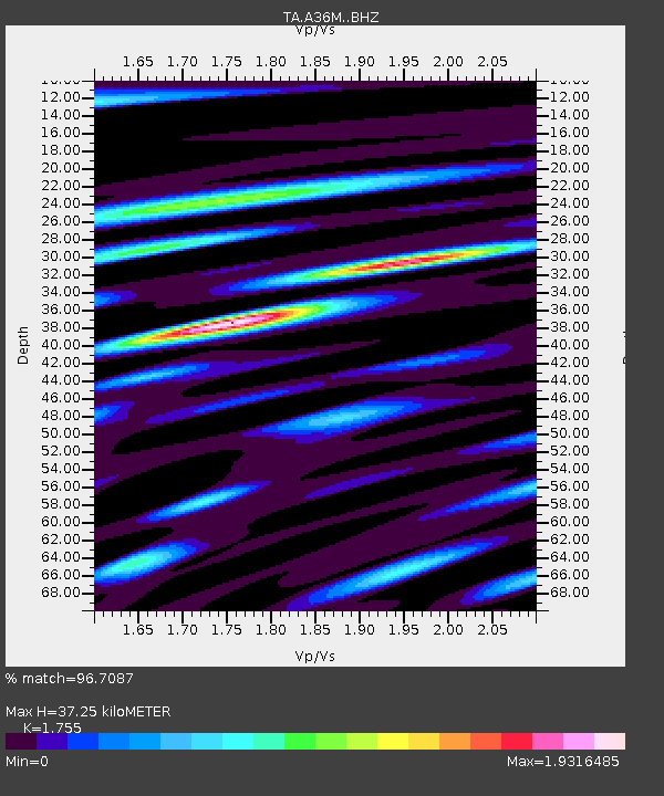
| Estimated Moho Depth: |
37.25 km |
| Estimated Crust Vp/Vs: |
1.75 |
| Assumed Crust Vp: |
6.24 km/s |
| Estimated Crust Vs: |
3.556 km/s |
| Estimated Crust Poisson's Ratio: |
0.26 |
|
| Radial Match: |
96.7087 % |
| Radial Bump: |
400 |
| Transverse Match: |
92.33842 % |
| Transverse Bump: |
400 |
| SOD ConfigId: |
7422571 |
| Insert Time: |
2019-04-21 16:45:11.188 +0000 |
| GWidth: |
2.5 |
| Max Bumps: |
400 |
| Tol: |
0.001 |
|
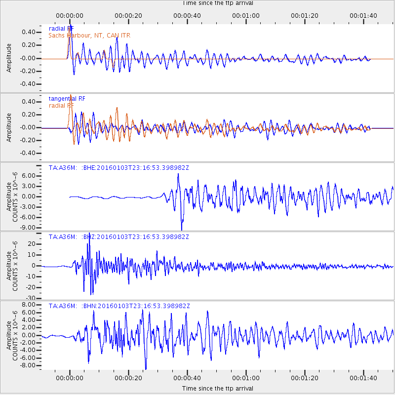
Signal To Noise
| Channel | StoN | STA | LTA |
| TA:A36M: :BHZ:20160103T23:16:53.398982Z | 20.860458 | 4.9216164E-6 | 2.3593041E-7 |
| TA:A36M: :BHN:20160103T23:16:53.398982Z | 2.5616179 | 7.164805E-7 | 2.7969844E-7 |
| TA:A36M: :BHE:20160103T23:16:53.398982Z | 4.511928 | 8.827294E-7 | 1.956435E-7 |
| Arrivals |
| Ps | 4.6 SECOND |
| PpPs | 16 SECOND |
| PsPs/PpSs | 21 SECOND |


