You are here: Home > Network List > TA - USArray Transportable Network (new EarthScope stations) Stations List
> Station C36M Paulatuk, NT, CAN > Earthquake Result Viewer
C36M Paulatuk, NT, CAN - Earthquake Result Viewer
| Earthquake location: |
Myanmar-India Border Region |
| Earthquake latitude/longitude: |
24.8/93.7 |
| Earthquake time(UTC): |
2016/01/03 (003) 23:05:22 GMT |
| Earthquake Depth: |
55 km |
| Earthquake Magnitude: |
6.7 MWW, 6.6 MWB |
| Earthquake Catalog/Contributor: |
NEIC PDE/NEIC COMCAT |
|
| Network: |
TA USArray Transportable Network (new EarthScope stations) |
| Station: |
C36M Paulatuk, NT, CAN |
| Lat/Lon: |
69.35 N/124.07 W |
| Elevation: |
10 m |
|
| Distance: |
82.2 deg |
| Az: |
12.656 deg |
| Baz: |
325.866 deg |
| Ray Param: |
0.04694554 |
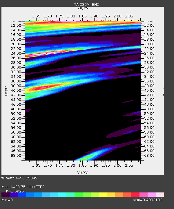
| Estimated Moho Depth: |
23.75 km |
| Estimated Crust Vp/Vs: |
1.69 |
| Assumed Crust Vp: |
6.459 km/s |
| Estimated Crust Vs: |
3.817 km/s |
| Estimated Crust Poisson's Ratio: |
0.23 |
|
| Radial Match: |
90.25849 % |
| Radial Bump: |
400 |
| Transverse Match: |
68.34968 % |
| Transverse Bump: |
400 |
| SOD ConfigId: |
7422571 |
| Insert Time: |
2019-04-21 16:45:12.285 +0000 |
| GWidth: |
2.5 |
| Max Bumps: |
400 |
| Tol: |
0.001 |
|

Signal To Noise
| Channel | StoN | STA | LTA |
| TA:C36M: :BHZ:20160103T23:17:06.124019Z | 26.791939 | 5.694649E-6 | 2.1255084E-7 |
| TA:C36M: :BHN:20160103T23:17:06.124019Z | 2.786384 | 1.1107339E-6 | 3.9862914E-7 |
| TA:C36M: :BHE:20160103T23:17:06.124019Z | 2.4763584 | 7.541086E-7 | 3.045232E-7 |
| Arrivals |
| Ps | 2.6 SECOND |
| PpPs | 9.6 SECOND |
| PsPs/PpSs | 12 SECOND |


