You are here: Home > Network List > TA - USArray Transportable Network (new EarthScope stations) Stations List
> Station I21K Tanana, AK, USA > Earthquake Result Viewer
I21K Tanana, AK, USA - Earthquake Result Viewer
| Earthquake location: |
Myanmar-India Border Region |
| Earthquake latitude/longitude: |
24.8/93.7 |
| Earthquake time(UTC): |
2016/01/03 (003) 23:05:22 GMT |
| Earthquake Depth: |
55 km |
| Earthquake Magnitude: |
6.7 MWW, 6.6 MWB |
| Earthquake Catalog/Contributor: |
NEIC PDE/NEIC COMCAT |
|
| Network: |
TA USArray Transportable Network (new EarthScope stations) |
| Station: |
I21K Tanana, AK, USA |
| Lat/Lon: |
65.18 N/151.98 W |
| Elevation: |
248 m |
|
| Distance: |
77.3 deg |
| Az: |
23.217 deg |
| Baz: |
301.944 deg |
| Ray Param: |
0.05033434 |
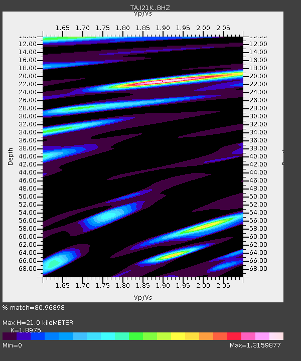
| Estimated Moho Depth: |
21.0 km |
| Estimated Crust Vp/Vs: |
1.90 |
| Assumed Crust Vp: |
6.566 km/s |
| Estimated Crust Vs: |
3.46 km/s |
| Estimated Crust Poisson's Ratio: |
0.31 |
|
| Radial Match: |
80.96898 % |
| Radial Bump: |
400 |
| Transverse Match: |
83.17316 % |
| Transverse Bump: |
400 |
| SOD ConfigId: |
7422571 |
| Insert Time: |
2019-04-21 16:45:15.915 +0000 |
| GWidth: |
2.5 |
| Max Bumps: |
400 |
| Tol: |
0.001 |
|

Signal To Noise
| Channel | StoN | STA | LTA |
| TA:I21K: :BHZ:20160103T23:16:39.450007Z | 4.356574 | 1.5305131E-6 | 3.5131114E-7 |
| TA:I21K: :BHN:20160103T23:16:39.450007Z | 1.2866952 | 4.404273E-7 | 3.4229342E-7 |
| TA:I21K: :BHE:20160103T23:16:39.450007Z | 1.0646992 | 4.4941987E-7 | 4.221097E-7 |
| Arrivals |
| Ps | 3.0 SECOND |
| PpPs | 9.0 SECOND |
| PsPs/PpSs | 12 SECOND |


