You are here: Home > Network List > YY13 - Exploring extensional tectonics beyond the Ethiopian Rift Stations List
> Station GOND University, Gondar, Ethiopia > Earthquake Result Viewer
GOND University, Gondar, Ethiopia - Earthquake Result Viewer
| Earthquake location: |
Myanmar-India Border Region |
| Earthquake latitude/longitude: |
24.8/93.7 |
| Earthquake time(UTC): |
2016/01/03 (003) 23:05:22 GMT |
| Earthquake Depth: |
55 km |
| Earthquake Magnitude: |
6.7 MWW, 6.6 MWB |
| Earthquake Catalog/Contributor: |
NEIC PDE/NEIC COMCAT |
|
| Network: |
YY Exploring extensional tectonics beyond the Ethiopian Rift |
| Station: |
GOND University, Gondar, Ethiopia |
| Lat/Lon: |
12.58 N/37.45 E |
| Elevation: |
2241 m |
|
| Distance: |
54.3 deg |
| Az: |
267.872 deg |
| Baz: |
68.437 deg |
| Ray Param: |
0.06541007 |
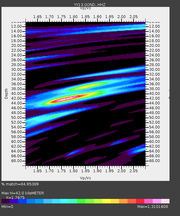
| Estimated Moho Depth: |
42.0 km |
| Estimated Crust Vp/Vs: |
1.77 |
| Assumed Crust Vp: |
6.464 km/s |
| Estimated Crust Vs: |
3.657 km/s |
| Estimated Crust Poisson's Ratio: |
0.26 |
|
| Radial Match: |
84.95389 % |
| Radial Bump: |
400 |
| Transverse Match: |
72.6029 % |
| Transverse Bump: |
400 |
| SOD ConfigId: |
7422571 |
| Insert Time: |
2019-04-21 16:45:57.624 +0000 |
| GWidth: |
2.5 |
| Max Bumps: |
400 |
| Tol: |
0.001 |
|

Signal To Noise
| Channel | StoN | STA | LTA |
| YY:GOND: :HHZ:20160103T23:14:11.989985Z | 29.923492 | 1.8501559E-6 | 6.1829546E-8 |
| YY:GOND: :HHN:20160103T23:14:11.989985Z | 8.121137 | 3.5068936E-7 | 4.3182297E-8 |
| YY:GOND: :HHE:20160103T23:14:11.989985Z | 14.813127 | 8.492302E-7 | 5.7329576E-8 |
| Arrivals |
| Ps | 5.3 SECOND |
| PpPs | 17 SECOND |
| PsPs/PpSs | 22 SECOND |


