You are here: Home > Network List > CI - Caltech Regional Seismic Network Stations List
> Station BEL Belle Mtn, Joshua Tree National Park, CA, USA > Earthquake Result Viewer
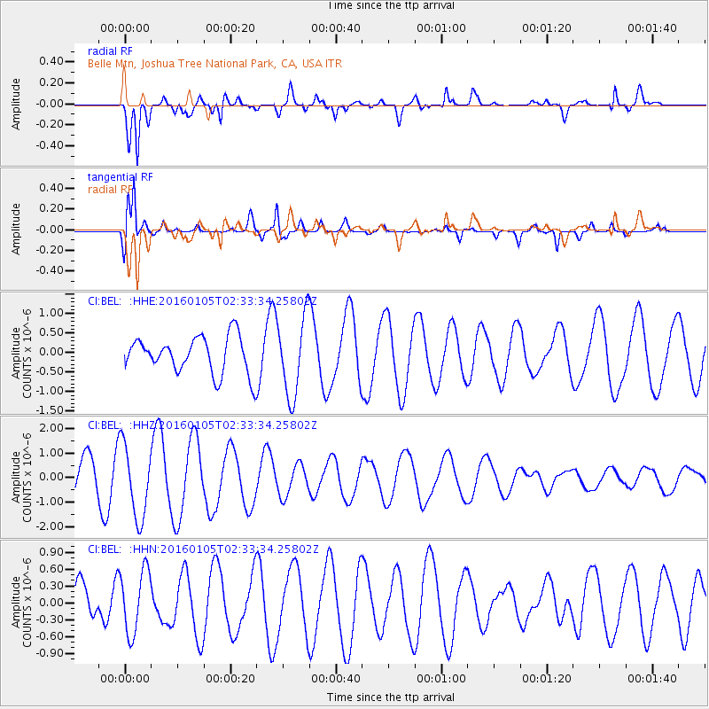
BEL Belle Mtn, Joshua Tree National Park, CA, USA - Earthquake Result Viewer
*The percent match for this event was below the threshold and hence no stack was calculated.
| Earthquake location: |
Southeast Of Shikoku, Japan |
| Earthquake latitude/longitude: |
30.6/132.8 |
| Earthquake time(UTC): |
2016/01/05 (005) 02:21:12 GMT |
| Earthquake Depth: |
10 km |
| Earthquake Magnitude: |
5.8 MB, 5.8 MWB |
| Earthquake Catalog/Contributor: |
NEIC PDE/NEIC COMCAT |
|
| Network: |
CI Caltech Regional Seismic Network |
| Station: |
BEL Belle Mtn, Joshua Tree National Park, CA, USA |
| Lat/Lon: |
34.00 N/116.00 W |
| Elevation: |
1388 m |
|
| Distance: |
88.7 deg |
| Az: |
50.782 deg |
| Baz: |
306.51 deg |
| Ray Param: |
$rayparam |
*The percent match for this event was below the threshold and hence was not used in the summary stack. |
|
| Radial Match: |
89.511375 % |
| Radial Bump: |
400 |
| Transverse Match: |
90.19359 % |
| Transverse Bump: |
400 |
| SOD ConfigId: |
7422571 |
| Insert Time: |
2019-04-21 16:48:08.369 +0000 |
| GWidth: |
2.5 |
| Max Bumps: |
400 |
| Tol: |
0.001 |
|
Signal To Noise
| Channel | StoN | STA | LTA |
| CI:BEL: :HHZ:20160105T02:33:34.25802Z | 2.8853943 | 1.4871775E-6 | 5.154157E-7 |
| CI:BEL: :HHN:20160105T02:33:34.25802Z | 1.6048427 | 5.666028E-7 | 3.5305814E-7 |
| CI:BEL: :HHE:20160105T02:33:34.25802Z | 2.1604168 | 1.0315194E-6 | 4.774632E-7 |
| Arrivals |
| Ps | |
| PpPs | |
| PsPs/PpSs | |


