You are here: Home > Network List > UW - Pacific Northwest Regional Seismic Network Stations List
> Station MRBL Marblemount, WA, USA > Earthquake Result Viewer
MRBL Marblemount, WA, USA - Earthquake Result Viewer
*The percent match for this event was below the threshold and hence no stack was calculated.
| Earthquake location: |
Southeast Of Shikoku, Japan |
| Earthquake latitude/longitude: |
30.6/132.8 |
| Earthquake time(UTC): |
2016/01/05 (005) 02:21:12 GMT |
| Earthquake Depth: |
10 km |
| Earthquake Magnitude: |
5.8 MB, 5.8 MWB |
| Earthquake Catalog/Contributor: |
NEIC PDE/NEIC COMCAT |
|
| Network: |
UW Pacific Northwest Regional Seismic Network |
| Station: |
MRBL Marblemount, WA, USA |
| Lat/Lon: |
48.52 N/121.48 W |
| Elevation: |
75 m |
|
| Distance: |
77.1 deg |
| Az: |
41.045 deg |
| Baz: |
301.657 deg |
| Ray Param: |
$rayparam |
*The percent match for this event was below the threshold and hence was not used in the summary stack. |
|
| Radial Match: |
49.046486 % |
| Radial Bump: |
400 |
| Transverse Match: |
45.549683 % |
| Transverse Bump: |
384 |
| SOD ConfigId: |
7422571 |
| Insert Time: |
2019-04-21 16:52:26.874 +0000 |
| GWidth: |
2.5 |
| Max Bumps: |
400 |
| Tol: |
0.001 |
|
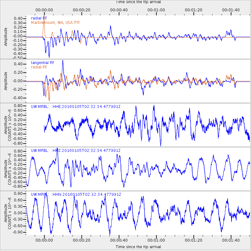
Signal To Noise
| Channel | StoN | STA | LTA |
| UW:MRBL: :HHZ:20160105T02:32:34.477991Z | 1.2238486 | 3.185548E-7 | 2.602894E-7 |
| UW:MRBL: :HHN:20160105T02:32:34.477991Z | 1.7700095 | 6.3801235E-7 | 3.6045702E-7 |
| UW:MRBL: :HHE:20160105T02:32:34.477991Z | 0.6468253 | 1.312953E-7 | 2.0298417E-7 |
| Arrivals |
| Ps | |
| PpPs | |
| PsPs/PpSs | |


