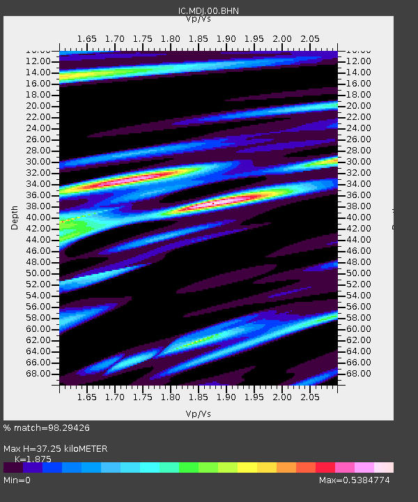
MDJ Mudanjiang, Heilongjiang Province, China - Earthquake Result Viewer

Earthquake location: Southern Sumatra, Indonesia
Earthquake latitude/longitude: -4.7/102.6
Earthquake time(UTC): 2001/02/13 (044) 19:28:30 GMT
Earthquake Depth: 36 km
Earthquake Magnitude: 6.2 MB, 7.2 MS, 7.4 MW, 7.0 ME
Earthquake Catalog/Contributor: WHDF/NEIC
Network: IC New China Digital Seismograph Network
Station: MDJ Mudanjiang, Heilongjiang Province, China
Lat/Lon: 44.62 N/129.59 E
Elevation: 250 m
Distance: 54.7 deg
Az: 23.422 deg
Baz: 213.694 deg
Ray Param: 0.065189555
Estimated Moho Depth: 37.25 km
Estimated Crust Vp/Vs: 1.88
Assumed Crust Vp: 6.459 km/s
Estimated Crust Vs: 3.445 km/s
Estimated Crust Poisson's Ratio: 0.30
Radial Match: 98.29426 %
Radial Bump: 385
Transverse Match: 88.24515 %
Transverse Bump: 400
SOD ConfigId: 3744
Insert Time: 2010-03-04 23:02:42.432 +0000
GWidth: 2.5
Max Bumps: 400
Tol: 0.001

Signal To Noise

ChannelStoNSTALTA
IC:MDJ:00:BHN:20010213T19:37:25.473013Z2.1261482.3972817E-71.12752346E-7
IC:MDJ:00:BHE:20010213T19:37:25.473013Z1.16568351.2838174E-71.1013431E-7
IC:MDJ:00:BHZ:20010213T19:37:25.473013Z2.02478653.9261906E-71.939064E-7
Arrivals
Ps5.3 SECOND
PpPs16 SECOND
PsPs/PpSs21 SECOND