You are here: Home > Network List > IC - New China Digital Seismograph Network Stations List
> Station MDJ Mudanjiang, Heilongjiang Province, China > Earthquake Result Viewer
MDJ Mudanjiang, Heilongjiang Province, China - Earthquake Result Viewer
| Earthquake location: |
Southeast Of Loyalty Islands |
| Earthquake latitude/longitude: |
-22.0/170.2 |
| Earthquake time(UTC): |
2001/02/28 (059) 12:30:14 GMT |
| Earthquake Depth: |
10 km |
| Earthquake Magnitude: |
6.0 MB, 6.5 MS, 6.7 MW, 6.5 MW |
| Earthquake Catalog/Contributor: |
WHDF/NEIC |
|
| Network: |
IC New China Digital Seismograph Network |
| Station: |
MDJ Mudanjiang, Heilongjiang Province, China |
| Lat/Lon: |
44.62 N/129.59 E |
| Elevation: |
250 m |
|
| Distance: |
76.0 deg |
| Az: |
331.365 deg |
| Baz: |
141.478 deg |
| Ray Param: |
0.0513178 |
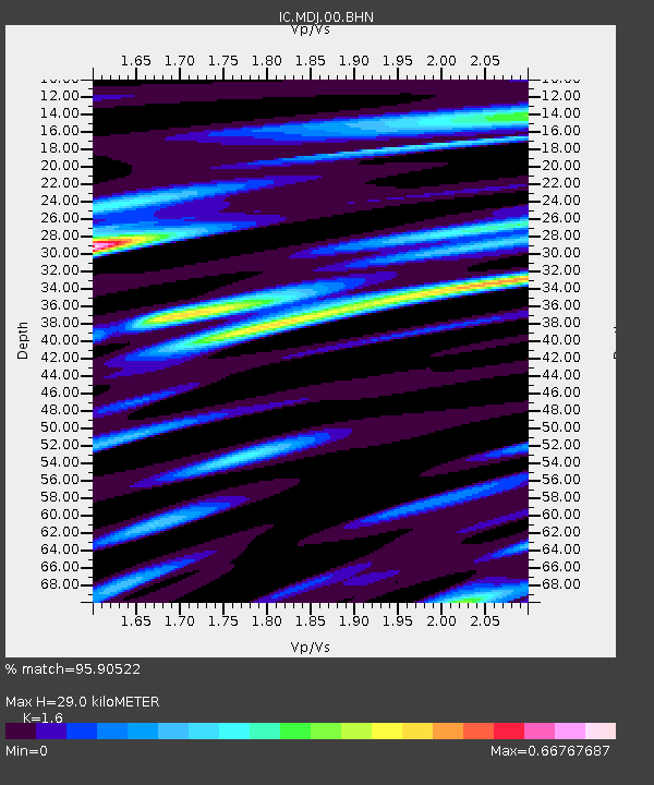
| Estimated Moho Depth: |
29.0 km |
| Estimated Crust Vp/Vs: |
1.60 |
| Assumed Crust Vp: |
6.459 km/s |
| Estimated Crust Vs: |
4.037 km/s |
| Estimated Crust Poisson's Ratio: |
0.18 |
|
| Radial Match: |
95.90522 % |
| Radial Bump: |
400 |
| Transverse Match: |
88.152756 % |
| Transverse Bump: |
400 |
| SOD ConfigId: |
3744 |
| Insert Time: |
2010-03-04 23:02:44.025 +0000 |
| GWidth: |
2.5 |
| Max Bumps: |
400 |
| Tol: |
0.001 |
|

Signal To Noise
| Channel | StoN | STA | LTA |
| IC:MDJ:00:BHN:20010228T12:41:29.68501Z | 2.0026438 | 1.4921487E-7 | 7.450894E-8 |
| IC:MDJ:00:BHE:20010228T12:41:29.68501Z | 1.7653613 | 1.3960762E-7 | 7.908161E-8 |
| IC:MDJ:00:BHZ:20010228T12:41:29.68501Z | 9.101489 | 7.639287E-7 | 8.3934474E-8 |
| Arrivals |
| Ps | 2.8 SECOND |
| PpPs | 11 SECOND |
| PsPs/PpSs | 14 SECOND |


