You are here: Home > Network List > TA - USArray Transportable Network (new EarthScope stations) Stations List
> Station L44A Lake County Forest Preserve, Grayslake, IL, USA > Earthquake Result Viewer
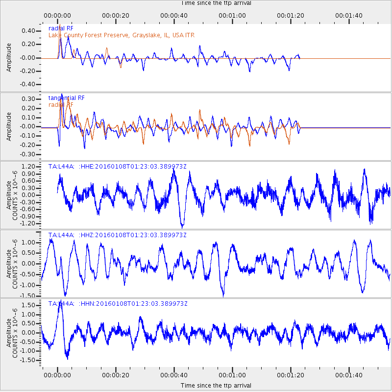
L44A Lake County Forest Preserve, Grayslake, IL, USA - Earthquake Result Viewer
*The percent match for this event was below the threshold and hence no stack was calculated.
| Earthquake location: |
Near Coast Of Central Chile |
| Earthquake latitude/longitude: |
-30.7/-71.7 |
| Earthquake time(UTC): |
2016/01/08 (008) 01:12:00 GMT |
| Earthquake Depth: |
31 km |
| Earthquake Magnitude: |
5.6 MWR |
| Earthquake Catalog/Contributor: |
NEIC PDE/NEIC COMCAT |
|
| Network: |
TA USArray Transportable Network (new EarthScope stations) |
| Station: |
L44A Lake County Forest Preserve, Grayslake, IL, USA |
| Lat/Lon: |
42.18 N/87.91 W |
| Elevation: |
202 m |
|
| Distance: |
74.0 deg |
| Az: |
347.515 deg |
| Baz: |
165.486 deg |
| Ray Param: |
$rayparam |
*The percent match for this event was below the threshold and hence was not used in the summary stack. |
|
| Radial Match: |
49.57511 % |
| Radial Bump: |
400 |
| Transverse Match: |
47.96686 % |
| Transverse Bump: |
400 |
| SOD ConfigId: |
7422571 |
| Insert Time: |
2019-04-21 17:10:41.685 +0000 |
| GWidth: |
2.5 |
| Max Bumps: |
400 |
| Tol: |
0.001 |
|
Signal To Noise
| Channel | StoN | STA | LTA |
| TA:L44A: :HHZ:20160108T01:23:03.389973Z | 1.6840516 | 6.9481626E-7 | 4.1258608E-7 |
| TA:L44A: :HHN:20160108T01:23:03.389973Z | 2.619858 | 1.0034234E-6 | 3.830068E-7 |
| TA:L44A: :HHE:20160108T01:23:03.389973Z | 1.1643591 | 3.7564996E-7 | 3.226238E-7 |
| Arrivals |
| Ps | |
| PpPs | |
| PsPs/PpSs | |


