You are here: Home > Network List > CI - Caltech Regional Seismic Network Stations List
> Station MPM Manuel Prospect Mine, California, USA > Earthquake Result Viewer
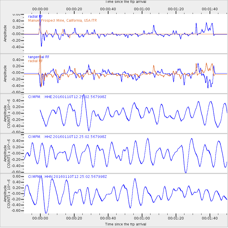
MPM Manuel Prospect Mine, California, USA - Earthquake Result Viewer
*The percent match for this event was below the threshold and hence no stack was calculated.
| Earthquake location: |
Pacific-Antarctic Ridge |
| Earthquake latitude/longitude: |
-57.7/-147.9 |
| Earthquake time(UTC): |
2016/01/10 (010) 12:12:02 GMT |
| Earthquake Depth: |
4.0 km |
| Earthquake Magnitude: |
5.6 mwb |
| Earthquake Catalog/Contributor: |
NEIC PDE/us |
|
| Network: |
CI Caltech Regional Seismic Network |
| Station: |
MPM Manuel Prospect Mine, California, USA |
| Lat/Lon: |
36.06 N/117.49 W |
| Elevation: |
185 m |
|
| Distance: |
96.8 deg |
| Az: |
24.437 deg |
| Baz: |
195.928 deg |
| Ray Param: |
$rayparam |
*The percent match for this event was below the threshold and hence was not used in the summary stack. |
|
| Radial Match: |
54.08303 % |
| Radial Bump: |
400 |
| Transverse Match: |
50.930817 % |
| Transverse Bump: |
400 |
| SOD ConfigId: |
7422571 |
| Insert Time: |
2019-04-21 17:14:44.424 +0000 |
| GWidth: |
2.5 |
| Max Bumps: |
400 |
| Tol: |
0.001 |
|
Signal To Noise
| Channel | StoN | STA | LTA |
| CI:MPM: :HHZ:20160110T12:25:02.567998Z | 2.0801635 | 2.6523486E-7 | 1.2750675E-7 |
| CI:MPM: :HHN:20160110T12:25:02.567998Z | 3.024497 | 5.077825E-7 | 1.678899E-7 |
| CI:MPM: :HHE:20160110T12:25:02.567998Z | 0.78438413 | 1.648882E-7 | 2.1021359E-7 |
| Arrivals |
| Ps | |
| PpPs | |
| PsPs/PpSs | |


