You are here: Home > Network List > G - GEOSCOPE Stations List
> Station PPTF Pamatai - Papeete - Tahiti island - French Polynesia, France > Earthquake Result Viewer
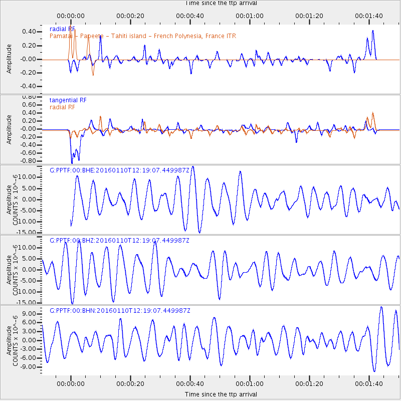
PPTF Pamatai - Papeete - Tahiti island - French Polynesia, France - Earthquake Result Viewer
*The percent match for this event was below the threshold and hence no stack was calculated.
| Earthquake location: |
Pacific-Antarctic Ridge |
| Earthquake latitude/longitude: |
-57.7/-147.9 |
| Earthquake time(UTC): |
2016/01/10 (010) 12:12:02 GMT |
| Earthquake Depth: |
4.0 km |
| Earthquake Magnitude: |
5.6 mwb |
| Earthquake Catalog/Contributor: |
NEIC PDE/us |
|
| Network: |
G GEOSCOPE |
| Station: |
PPTF Pamatai - Papeete - Tahiti island - French Polynesia, France |
| Lat/Lon: |
17.59 S/149.57 W |
| Elevation: |
705 m |
|
| Distance: |
40.0 deg |
| Az: |
357.602 deg |
| Baz: |
178.649 deg |
| Ray Param: |
$rayparam |
*The percent match for this event was below the threshold and hence was not used in the summary stack. |
|
| Radial Match: |
52.832577 % |
| Radial Bump: |
400 |
| Transverse Match: |
61.959007 % |
| Transverse Bump: |
400 |
| SOD ConfigId: |
7422571 |
| Insert Time: |
2019-04-21 17:15:09.682 +0000 |
| GWidth: |
2.5 |
| Max Bumps: |
400 |
| Tol: |
0.001 |
|
Signal To Noise
| Channel | StoN | STA | LTA |
| G:PPTF:00:BHZ:20160110T12:19:07.449987Z | 2.4897444 | 9.674002E-6 | 3.8855405E-6 |
| G:PPTF:00:BHN:20160110T12:19:07.449987Z | 0.50150406 | 2.2996235E-6 | 4.5854536E-6 |
| G:PPTF:00:BHE:20160110T12:19:07.449987Z | 0.6106563 | 3.3447213E-6 | 5.4772568E-6 |
| Arrivals |
| Ps | |
| PpPs | |
| PsPs/PpSs | |


