You are here: Home > Network List > IC - New China Digital Seismograph Network Stations List
> Station MDJ Mudanjiang, Heilongjiang Province, China > Earthquake Result Viewer
MDJ Mudanjiang, Heilongjiang Province, China - Earthquake Result Viewer
| Earthquake location: |
Solomon Islands |
| Earthquake latitude/longitude: |
-10.5/160.8 |
| Earthquake time(UTC): |
2003/01/20 (020) 08:43:06 GMT |
| Earthquake Depth: |
33 km |
| Earthquake Magnitude: |
6.7 MB, 7.8 MS, 7.3 MW, 7.2 MW |
| Earthquake Catalog/Contributor: |
WHDF/NEIC |
|
| Network: |
IC New China Digital Seismograph Network |
| Station: |
MDJ Mudanjiang, Heilongjiang Province, China |
| Lat/Lon: |
44.62 N/129.59 E |
| Elevation: |
250 m |
|
| Distance: |
61.7 deg |
| Az: |
335.167 deg |
| Baz: |
144.665 deg |
| Ray Param: |
0.060663022 |
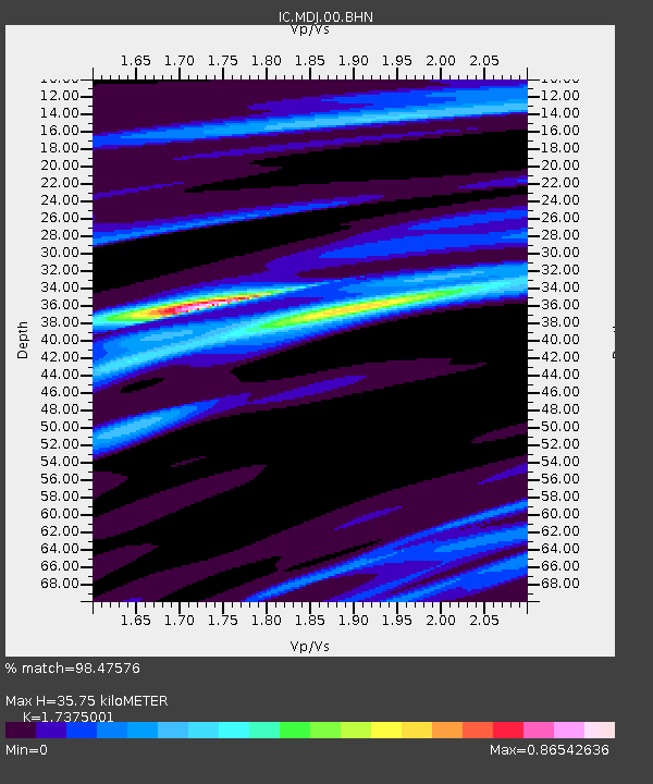
| Estimated Moho Depth: |
35.75 km |
| Estimated Crust Vp/Vs: |
1.74 |
| Assumed Crust Vp: |
6.459 km/s |
| Estimated Crust Vs: |
3.718 km/s |
| Estimated Crust Poisson's Ratio: |
0.25 |
|
| Radial Match: |
98.47576 % |
| Radial Bump: |
265 |
| Transverse Match: |
93.2675 % |
| Transverse Bump: |
400 |
| SOD ConfigId: |
4714 |
| Insert Time: |
2010-03-04 23:04:48.517 +0000 |
| GWidth: |
2.5 |
| Max Bumps: |
400 |
| Tol: |
0.001 |
|

Signal To Noise
| Channel | StoN | STA | LTA |
| IC:MDJ:00:BHN:20030120T08:52:50.072014Z | 15.49859 | 2.134975E-6 | 1.3775285E-7 |
| IC:MDJ:00:BHE:20030120T08:52:50.072014Z | 5.4517455 | 1.1083084E-6 | 2.0329423E-7 |
| IC:MDJ:00:BHZ:20030120T08:52:50.072014Z | 42.245487 | 6.750319E-6 | 1.5978792E-7 |
| Arrivals |
| Ps | 4.3 SECOND |
| PpPs | 14 SECOND |
| PsPs/PpSs | 19 SECOND |


