You are here: Home > Network List > AU - Australian Seismological Centre Stations List
> Station MUN Mundaring, Western Australia > Earthquake Result Viewer
MUN Mundaring, Western Australia - Earthquake Result Viewer
| Earthquake location: |
Talaud Islands, Indonesia |
| Earthquake latitude/longitude: |
3.9/126.9 |
| Earthquake time(UTC): |
2016/01/11 (011) 16:38:07 GMT |
| Earthquake Depth: |
21 km |
| Earthquake Magnitude: |
6.5 MWW, 6.4 MWB, 6.9 MI |
| Earthquake Catalog/Contributor: |
NEIC PDE/NEIC COMCAT |
|
| Network: |
AU Australian Seismological Centre |
| Station: |
MUN Mundaring, Western Australia |
| Lat/Lon: |
31.98 S/116.21 E |
| Elevation: |
253 m |
|
| Distance: |
37.1 deg |
| Az: |
195.119 deg |
| Baz: |
17.832 deg |
| Ray Param: |
0.07631633 |
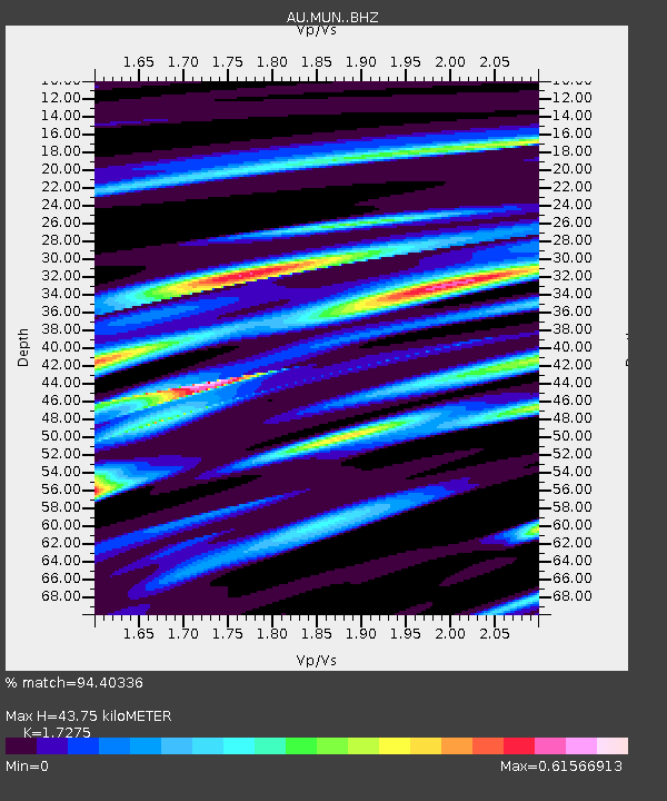
| Estimated Moho Depth: |
43.75 km |
| Estimated Crust Vp/Vs: |
1.73 |
| Assumed Crust Vp: |
6.419 km/s |
| Estimated Crust Vs: |
3.716 km/s |
| Estimated Crust Poisson's Ratio: |
0.25 |
|
| Radial Match: |
94.40336 % |
| Radial Bump: |
279 |
| Transverse Match: |
75.341934 % |
| Transverse Bump: |
400 |
| SOD ConfigId: |
7422571 |
| Insert Time: |
2019-04-21 17:18:08.363 +0000 |
| GWidth: |
2.5 |
| Max Bumps: |
400 |
| Tol: |
0.001 |
|

Signal To Noise
| Channel | StoN | STA | LTA |
| AU:MUN: :BHZ:20160111T16:44:44.968987Z | 8.40963 | 2.197363E-6 | 2.612913E-7 |
| AU:MUN: :BHN:20160111T16:44:44.968987Z | 10.440897 | 1.2923562E-6 | 1.2377828E-7 |
| AU:MUN: :BHE:20160111T16:44:44.968987Z | 5.183066 | 8.2546865E-7 | 1.5926263E-7 |
| Arrivals |
| Ps | 5.3 SECOND |
| PpPs | 17 SECOND |
| PsPs/PpSs | 23 SECOND |


