You are here: Home > Network List > CB - China National Seismic Network Stations List
> Station SNY Shenyang,Liaoning Province > Earthquake Result Viewer
SNY Shenyang,Liaoning Province - Earthquake Result Viewer
| Earthquake location: |
Talaud Islands, Indonesia |
| Earthquake latitude/longitude: |
3.9/126.9 |
| Earthquake time(UTC): |
2016/01/11 (011) 16:38:07 GMT |
| Earthquake Depth: |
21 km |
| Earthquake Magnitude: |
6.5 MWW, 6.4 MWB, 6.9 MI |
| Earthquake Catalog/Contributor: |
NEIC PDE/NEIC COMCAT |
|
| Network: |
CB China National Seismic Network |
| Station: |
SNY Shenyang,Liaoning Province |
| Lat/Lon: |
41.83 N/123.58 E |
| Elevation: |
54 m |
|
| Distance: |
37.9 deg |
| Az: |
355.999 deg |
| Baz: |
174.655 deg |
| Ray Param: |
0.0758374 |
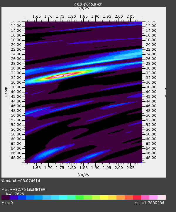
| Estimated Moho Depth: |
32.75 km |
| Estimated Crust Vp/Vs: |
1.76 |
| Assumed Crust Vp: |
6.464 km/s |
| Estimated Crust Vs: |
3.667 km/s |
| Estimated Crust Poisson's Ratio: |
0.26 |
|
| Radial Match: |
93.976616 % |
| Radial Bump: |
295 |
| Transverse Match: |
78.33164 % |
| Transverse Bump: |
400 |
| SOD ConfigId: |
7422571 |
| Insert Time: |
2019-04-21 17:18:27.708 +0000 |
| GWidth: |
2.5 |
| Max Bumps: |
400 |
| Tol: |
0.001 |
|

Signal To Noise
| Channel | StoN | STA | LTA |
| CB:SNY:00:BHZ:20160111T16:44:51.679985Z | 25.220818 | 4.9438686E-6 | 1.9602334E-7 |
| CB:SNY:00:BHN:20160111T16:44:51.679985Z | 16.259457 | 3.0397443E-6 | 1.8695239E-7 |
| CB:SNY:00:BHE:20160111T16:44:51.679985Z | 0.8701253 | 1.391562E-7 | 1.5992663E-7 |
| Arrivals |
| Ps | 4.2 SECOND |
| PpPs | 13 SECOND |
| PsPs/PpSs | 17 SECOND |


