You are here: Home > Network List > CN - Canadian National Seismograph Network Stations List
> Station INK INUVIK, NT > Earthquake Result Viewer
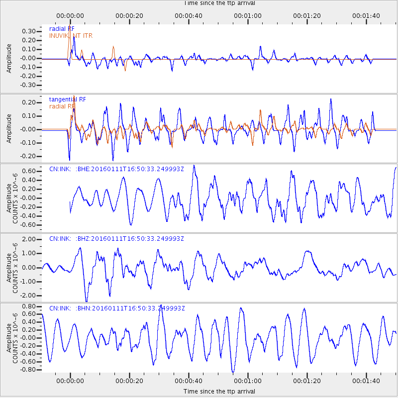
INK INUVIK, NT - Earthquake Result Viewer
*The percent match for this event was below the threshold and hence no stack was calculated.
| Earthquake location: |
Talaud Islands, Indonesia |
| Earthquake latitude/longitude: |
3.9/126.9 |
| Earthquake time(UTC): |
2016/01/11 (011) 16:38:07 GMT |
| Earthquake Depth: |
21 km |
| Earthquake Magnitude: |
6.5 MWW, 6.4 MWB, 6.9 MI |
| Earthquake Catalog/Contributor: |
NEIC PDE/NEIC COMCAT |
|
| Network: |
CN Canadian National Seismograph Network |
| Station: |
INK INUVIK, NT |
| Lat/Lon: |
68.31 N/133.53 W |
| Elevation: |
44 m |
|
| Distance: |
90.0 deg |
| Az: |
21.504 deg |
| Baz: |
280.339 deg |
| Ray Param: |
$rayparam |
*The percent match for this event was below the threshold and hence was not used in the summary stack. |
|
| Radial Match: |
64.21767 % |
| Radial Bump: |
400 |
| Transverse Match: |
74.87887 % |
| Transverse Bump: |
400 |
| SOD ConfigId: |
7422571 |
| Insert Time: |
2019-04-21 17:18:33.838 +0000 |
| GWidth: |
2.5 |
| Max Bumps: |
400 |
| Tol: |
0.001 |
|
Signal To Noise
| Channel | StoN | STA | LTA |
| CN:INK: :BHZ:20160111T16:50:33.249993Z | 2.9603586 | 7.707376E-7 | 2.6035278E-7 |
| CN:INK: :BHN:20160111T16:50:33.249993Z | 0.9077813 | 2.9351662E-7 | 3.2333406E-7 |
| CN:INK: :BHE:20160111T16:50:33.249993Z | 1.4072977 | 3.0944423E-7 | 2.1988541E-7 |
| Arrivals |
| Ps | |
| PpPs | |
| PsPs/PpSs | |


