You are here: Home > Network List > GE - GEOFON Stations List
> Station SOCY GEOFON Station Socotra, Yemen > Earthquake Result Viewer
SOCY GEOFON Station Socotra, Yemen - Earthquake Result Viewer
| Earthquake location: |
Talaud Islands, Indonesia |
| Earthquake latitude/longitude: |
3.9/126.9 |
| Earthquake time(UTC): |
2016/01/11 (011) 16:38:07 GMT |
| Earthquake Depth: |
21 km |
| Earthquake Magnitude: |
6.5 MWW, 6.4 MWB, 6.9 MI |
| Earthquake Catalog/Contributor: |
NEIC PDE/NEIC COMCAT |
|
| Network: |
GE GEOFON |
| Station: |
SOCY GEOFON Station Socotra, Yemen |
| Lat/Lon: |
12.19 N/53.99 E |
| Elevation: |
804 m |
|
| Distance: |
72.5 deg |
| Az: |
281.494 deg |
| Baz: |
89.769 deg |
| Ray Param: |
0.0536188 |
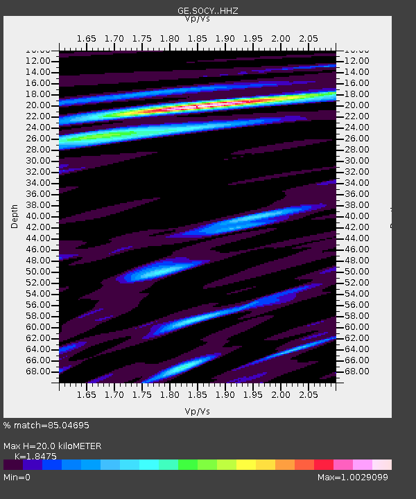
| Estimated Moho Depth: |
20.0 km |
| Estimated Crust Vp/Vs: |
1.85 |
| Assumed Crust Vp: |
4.662 km/s |
| Estimated Crust Vs: |
2.524 km/s |
| Estimated Crust Poisson's Ratio: |
0.29 |
|
| Radial Match: |
85.04695 % |
| Radial Bump: |
400 |
| Transverse Match: |
89.93447 % |
| Transverse Bump: |
400 |
| SOD ConfigId: |
7422571 |
| Insert Time: |
2019-04-21 17:18:47.385 +0000 |
| GWidth: |
2.5 |
| Max Bumps: |
400 |
| Tol: |
0.001 |
|

Signal To Noise
| Channel | StoN | STA | LTA |
| GE:SOCY: :HHZ:20160111T16:49:00.658013Z | 18.275133 | 1.6139049E-6 | 8.831153E-8 |
| GE:SOCY: :HHN:20160111T16:49:00.658013Z | 3.9549751 | 2.9732897E-7 | 7.517846E-8 |
| GE:SOCY: :HHE:20160111T16:49:00.658013Z | 3.0859091 | 9.0666873E-7 | 2.9380928E-7 |
| Arrivals |
| Ps | 3.7 SECOND |
| PpPs | 12 SECOND |
| PsPs/PpSs | 16 SECOND |


