You are here: Home > Network List > KO - Kandilli Observatory Digital Broadband Seismic Network Stations List
> Station GAZ Gaziantep-Turkey > Earthquake Result Viewer
GAZ Gaziantep-Turkey - Earthquake Result Viewer
| Earthquake location: |
Talaud Islands, Indonesia |
| Earthquake latitude/longitude: |
3.9/126.9 |
| Earthquake time(UTC): |
2016/01/11 (011) 16:38:07 GMT |
| Earthquake Depth: |
21 km |
| Earthquake Magnitude: |
6.5 MWW, 6.4 MWB, 6.9 MI |
| Earthquake Catalog/Contributor: |
NEIC PDE/NEIC COMCAT |
|
| Network: |
KO Kandilli Observatory Digital Broadband Seismic Network |
| Station: |
GAZ Gaziantep-Turkey |
| Lat/Lon: |
37.17 N/37.21 E |
| Elevation: |
992 m |
|
| Distance: |
87.4 deg |
| Az: |
306.911 deg |
| Baz: |
87.138 deg |
| Ray Param: |
0.0433212 |
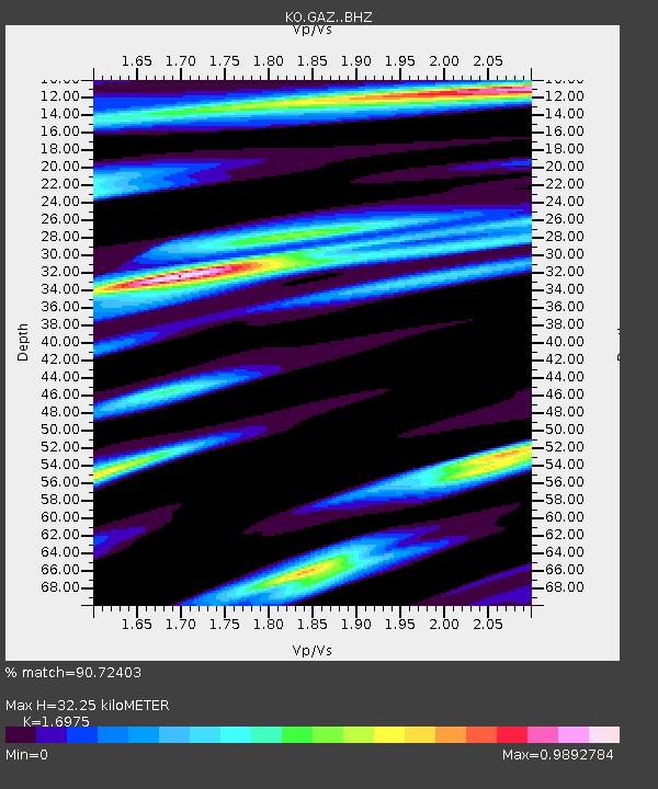
| Estimated Moho Depth: |
32.25 km |
| Estimated Crust Vp/Vs: |
1.70 |
| Assumed Crust Vp: |
6.247 km/s |
| Estimated Crust Vs: |
3.68 km/s |
| Estimated Crust Poisson's Ratio: |
0.23 |
|
| Radial Match: |
90.72403 % |
| Radial Bump: |
400 |
| Transverse Match: |
86.36095 % |
| Transverse Bump: |
400 |
| SOD ConfigId: |
7422571 |
| Insert Time: |
2019-04-21 17:19:32.894 +0000 |
| GWidth: |
2.5 |
| Max Bumps: |
400 |
| Tol: |
0.001 |
|

Signal To Noise
| Channel | StoN | STA | LTA |
| KO:GAZ: :BHZ:20160111T16:50:21.140007Z | 36.730434 | 2.7704998E-6 | 7.5427906E-8 |
| KO:GAZ: :BHN:20160111T16:50:21.140007Z | 2.1986303 | 2.1718925E-7 | 9.878389E-8 |
| KO:GAZ: :BHE:20160111T16:50:21.140007Z | 10.115761 | 7.532272E-7 | 7.446075E-8 |
| Arrivals |
| Ps | 3.7 SECOND |
| PpPs | 14 SECOND |
| PsPs/PpSs | 17 SECOND |


