You are here: Home > Network List > KR - Kyrgyz Digital Network Stations List
> Station ANVS Anan'evo, Kyrgyzstan > Earthquake Result Viewer
ANVS Anan'evo, Kyrgyzstan - Earthquake Result Viewer
| Earthquake location: |
Talaud Islands, Indonesia |
| Earthquake latitude/longitude: |
3.9/126.9 |
| Earthquake time(UTC): |
2016/01/11 (011) 16:38:07 GMT |
| Earthquake Depth: |
21 km |
| Earthquake Magnitude: |
6.5 MWW, 6.4 MWB, 6.9 MI |
| Earthquake Catalog/Contributor: |
NEIC PDE/NEIC COMCAT |
|
| Network: |
KR Kyrgyz Digital Network |
| Station: |
ANVS Anan'evo, Kyrgyzstan |
| Lat/Lon: |
42.79 N/77.67 E |
| Elevation: |
1864 m |
|
| Distance: |
58.3 deg |
| Az: |
319.089 deg |
| Baz: |
117.428 deg |
| Ray Param: |
0.0628996 |
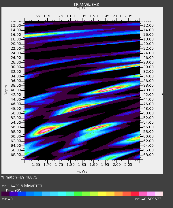
| Estimated Moho Depth: |
39.5 km |
| Estimated Crust Vp/Vs: |
1.97 |
| Assumed Crust Vp: |
6.306 km/s |
| Estimated Crust Vs: |
3.209 km/s |
| Estimated Crust Poisson's Ratio: |
0.33 |
|
| Radial Match: |
89.46875 % |
| Radial Bump: |
400 |
| Transverse Match: |
81.428764 % |
| Transverse Bump: |
400 |
| SOD ConfigId: |
7422571 |
| Insert Time: |
2019-04-21 17:19:35.512 +0000 |
| GWidth: |
2.5 |
| Max Bumps: |
400 |
| Tol: |
0.001 |
|

Signal To Noise
| Channel | StoN | STA | LTA |
| KR:ANVS: :BHZ:20160111T16:47:29.124993Z | 22.39457 | 1.9568377E-6 | 8.738E-8 |
| KR:ANVS: :BHN:20160111T16:47:29.124993Z | 6.5920243 | 5.0872836E-7 | 7.717331E-8 |
| KR:ANVS: :BHE:20160111T16:47:29.124993Z | 11.886771 | 8.131769E-7 | 6.8410245E-8 |
| Arrivals |
| Ps | 6.3 SECOND |
| PpPs | 18 SECOND |
| PsPs/PpSs | 24 SECOND |


