You are here: Home > Network List > S - Seismographs in Schools Projects Stations List
> Station AUMOU Moura State High School, QLD > Earthquake Result Viewer
AUMOU Moura State High School, QLD - Earthquake Result Viewer
| Earthquake location: |
Talaud Islands, Indonesia |
| Earthquake latitude/longitude: |
3.9/126.9 |
| Earthquake time(UTC): |
2016/01/11 (011) 16:38:07 GMT |
| Earthquake Depth: |
21 km |
| Earthquake Magnitude: |
6.5 MWW, 6.4 MWB, 6.9 MI |
| Earthquake Catalog/Contributor: |
NEIC PDE/NEIC COMCAT |
|
| Network: |
S Seismographs in Schools Projects |
| Station: |
AUMOU Moura State High School, QLD |
| Lat/Lon: |
24.58 S/149.98 E |
| Elevation: |
153 m |
|
| Distance: |
36.1 deg |
| Az: |
142.672 deg |
| Baz: |
318.355 deg |
| Ray Param: |
0.0768287 |
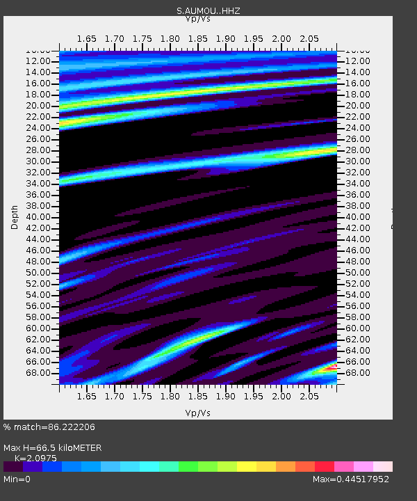
| Estimated Moho Depth: |
66.5 km |
| Estimated Crust Vp/Vs: |
2.10 |
| Assumed Crust Vp: |
6.316 km/s |
| Estimated Crust Vs: |
3.011 km/s |
| Estimated Crust Poisson's Ratio: |
0.35 |
|
| Radial Match: |
86.222206 % |
| Radial Bump: |
266 |
| Transverse Match: |
78.42152 % |
| Transverse Bump: |
400 |
| SOD ConfigId: |
7422571 |
| Insert Time: |
2019-04-21 17:20:16.486 +0000 |
| GWidth: |
2.5 |
| Max Bumps: |
400 |
| Tol: |
0.001 |
|

Signal To Noise
| Channel | StoN | STA | LTA |
| S:AUMOU: :HHZ:20160111T16:44:36.980004Z | 8.894546 | 2.900171E-6 | 3.2606172E-7 |
| S:AUMOU: :HHN:20160111T16:44:36.980004Z | 3.109282 | 1.3612741E-6 | 4.3780983E-7 |
| S:AUMOU: :HHE:20160111T16:44:36.980004Z | 1.0454532 | 9.148866E-7 | 8.7511E-7 |
| Arrivals |
| Ps | 12 SECOND |
| PpPs | 31 SECOND |
| PsPs/PpSs | 43 SECOND |


