You are here: Home > Network List > S - Seismographs in Schools Projects Stations List
> Station AUUHS Ulladulla High School, Ulladulla, NSW > Earthquake Result Viewer
AUUHS Ulladulla High School, Ulladulla, NSW - Earthquake Result Viewer
| Earthquake location: |
Talaud Islands, Indonesia |
| Earthquake latitude/longitude: |
3.9/126.9 |
| Earthquake time(UTC): |
2016/01/11 (011) 16:38:07 GMT |
| Earthquake Depth: |
21 km |
| Earthquake Magnitude: |
6.5 MWW, 6.4 MWB, 6.9 MI |
| Earthquake Catalog/Contributor: |
NEIC PDE/NEIC COMCAT |
|
| Network: |
S Seismographs in Schools Projects |
| Station: |
AUUHS Ulladulla High School, Ulladulla, NSW |
| Lat/Lon: |
35.36 S/150.47 E |
| Elevation: |
44 m |
|
| Distance: |
44.9 deg |
| Az: |
152.36 deg |
| Baz: |
325.508 deg |
| Ray Param: |
0.07162493 |
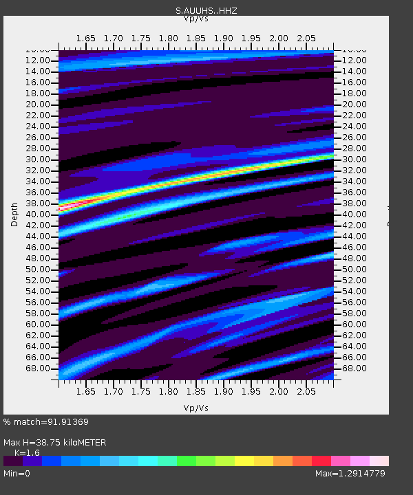
| Estimated Moho Depth: |
38.75 km |
| Estimated Crust Vp/Vs: |
1.60 |
| Assumed Crust Vp: |
6.472 km/s |
| Estimated Crust Vs: |
4.045 km/s |
| Estimated Crust Poisson's Ratio: |
0.18 |
|
| Radial Match: |
91.91369 % |
| Radial Bump: |
382 |
| Transverse Match: |
58.06702 % |
| Transverse Bump: |
400 |
| SOD ConfigId: |
7422571 |
| Insert Time: |
2019-04-21 17:20:23.477 +0000 |
| GWidth: |
2.5 |
| Max Bumps: |
400 |
| Tol: |
0.001 |
|

Signal To Noise
| Channel | StoN | STA | LTA |
| S:AUUHS: :HHZ:20160111T16:45:49.200005Z | 8.311824 | 2.439914E-6 | 2.9354737E-7 |
| S:AUUHS: :HHN:20160111T16:45:49.200005Z | 4.488477 | 1.0990149E-6 | 2.448525E-7 |
| S:AUUHS: :HHE:20160111T16:45:49.200005Z | 0.9671508 | 7.6854667E-7 | 7.946503E-7 |
| Arrivals |
| Ps | 3.9 SECOND |
| PpPs | 14 SECOND |
| PsPs/PpSs | 18 SECOND |


