You are here: Home > Network List > TA - USArray Transportable Network (new EarthScope stations) Stations List
> Station A21K Barrow, AK, USA > Earthquake Result Viewer
A21K Barrow, AK, USA - Earthquake Result Viewer
| Earthquake location: |
Talaud Islands, Indonesia |
| Earthquake latitude/longitude: |
3.9/126.9 |
| Earthquake time(UTC): |
2016/01/11 (011) 16:38:07 GMT |
| Earthquake Depth: |
21 km |
| Earthquake Magnitude: |
6.5 MWW, 6.4 MWB, 6.9 MI |
| Earthquake Catalog/Contributor: |
NEIC PDE/NEIC COMCAT |
|
| Network: |
TA USArray Transportable Network (new EarthScope stations) |
| Station: |
A21K Barrow, AK, USA |
| Lat/Lon: |
71.32 N/156.62 W |
| Elevation: |
577 m |
|
| Distance: |
82.0 deg |
| Az: |
18.442 deg |
| Baz: |
258.427 deg |
| Ray Param: |
0.04713757 |
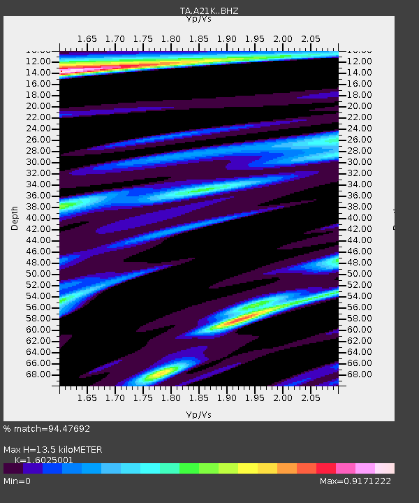
| Estimated Moho Depth: |
13.5 km |
| Estimated Crust Vp/Vs: |
1.60 |
| Assumed Crust Vp: |
6.048 km/s |
| Estimated Crust Vs: |
3.774 km/s |
| Estimated Crust Poisson's Ratio: |
0.18 |
|
| Radial Match: |
94.47692 % |
| Radial Bump: |
400 |
| Transverse Match: |
84.73595 % |
| Transverse Bump: |
400 |
| SOD ConfigId: |
7422571 |
| Insert Time: |
2019-04-21 17:20:25.718 +0000 |
| GWidth: |
2.5 |
| Max Bumps: |
400 |
| Tol: |
0.001 |
|
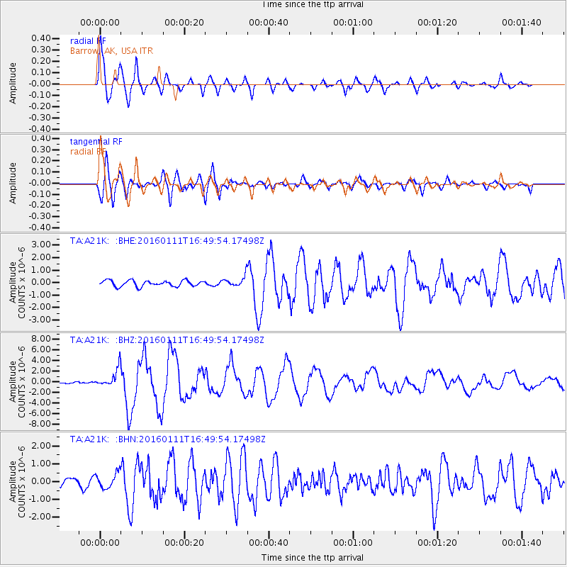
Signal To Noise
| Channel | StoN | STA | LTA |
| TA:A21K: :BHZ:20160111T16:49:54.17498Z | 10.069787 | 1.8011679E-6 | 1.7886852E-7 |
| TA:A21K: :BHN:20160111T16:49:54.17498Z | 2.2567503 | 4.2970998E-7 | 1.9041096E-7 |
| TA:A21K: :BHE:20160111T16:49:54.17498Z | 2.0460012 | 4.8205345E-7 | 2.3560762E-7 |
| Arrivals |
| Ps | 1.4 SECOND |
| PpPs | 5.7 SECOND |
| PsPs/PpSs | 7.0 SECOND |


