You are here: Home > Network List > TA - USArray Transportable Network (new EarthScope stations) Stations List
> Station M31M Drury Creek, Yukon, CA > Earthquake Result Viewer
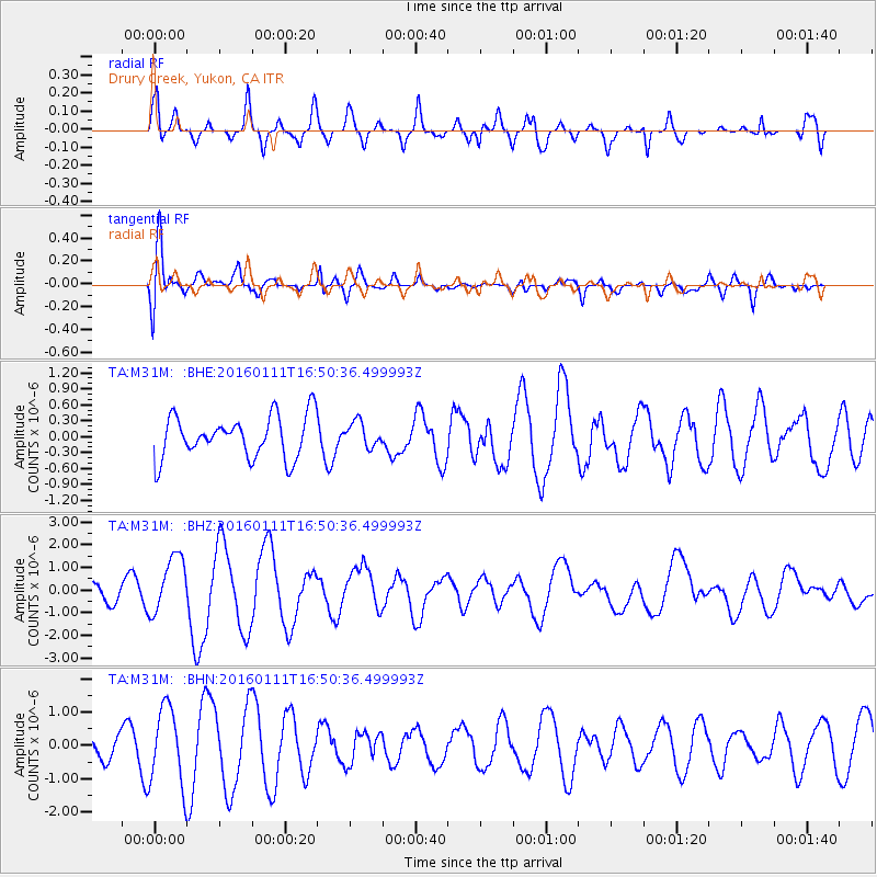
M31M Drury Creek, Yukon, CA - Earthquake Result Viewer
*The percent match for this event was below the threshold and hence no stack was calculated.
| Earthquake location: |
Talaud Islands, Indonesia |
| Earthquake latitude/longitude: |
3.9/126.9 |
| Earthquake time(UTC): |
2016/01/11 (011) 16:38:07 GMT |
| Earthquake Depth: |
21 km |
| Earthquake Magnitude: |
6.5 MWW, 6.4 MWB, 6.9 MI |
| Earthquake Catalog/Contributor: |
NEIC PDE/NEIC COMCAT |
|
| Network: |
TA USArray Transportable Network (new EarthScope stations) |
| Station: |
M31M Drury Creek, Yukon, CA |
| Lat/Lon: |
62.20 N/134.39 W |
| Elevation: |
639 m |
|
| Distance: |
90.7 deg |
| Az: |
27.606 deg |
| Baz: |
279.517 deg |
| Ray Param: |
$rayparam |
*The percent match for this event was below the threshold and hence was not used in the summary stack. |
|
| Radial Match: |
62.922813 % |
| Radial Bump: |
400 |
| Transverse Match: |
77.496155 % |
| Transverse Bump: |
400 |
| SOD ConfigId: |
7422571 |
| Insert Time: |
2019-04-21 17:20:36.911 +0000 |
| GWidth: |
2.5 |
| Max Bumps: |
400 |
| Tol: |
0.001 |
|
Signal To Noise
| Channel | StoN | STA | LTA |
| TA:M31M: :BHZ:20160111T16:50:36.499993Z | 3.7024298 | 1.257205E-6 | 3.3956215E-7 |
| TA:M31M: :BHN:20160111T16:50:36.499993Z | 3.330294 | 1.1629478E-6 | 3.4920276E-7 |
| TA:M31M: :BHE:20160111T16:50:36.499993Z | 0.5964155 | 2.351682E-7 | 3.9430265E-7 |
| Arrivals |
| Ps | |
| PpPs | |
| PsPs/PpSs | |


