You are here: Home > Network List > XL12 - Hangay Dome, Mongolia Stations List
> Station HV01 HV01 > Earthquake Result Viewer
HV01 HV01 - Earthquake Result Viewer
| Earthquake location: |
Talaud Islands, Indonesia |
| Earthquake latitude/longitude: |
3.9/126.9 |
| Earthquake time(UTC): |
2016/01/11 (011) 16:38:07 GMT |
| Earthquake Depth: |
21 km |
| Earthquake Magnitude: |
6.5 MWW, 6.4 MWB, 6.9 MI |
| Earthquake Catalog/Contributor: |
NEIC PDE/NEIC COMCAT |
|
| Network: |
XL Hangay Dome, Mongolia |
| Station: |
HV01 HV01 |
| Lat/Lon: |
51.39 N/99.33 E |
| Elevation: |
1539 m |
|
| Distance: |
52.7 deg |
| Az: |
338.636 deg |
| Baz: |
144.54 deg |
| Ray Param: |
0.06658851 |
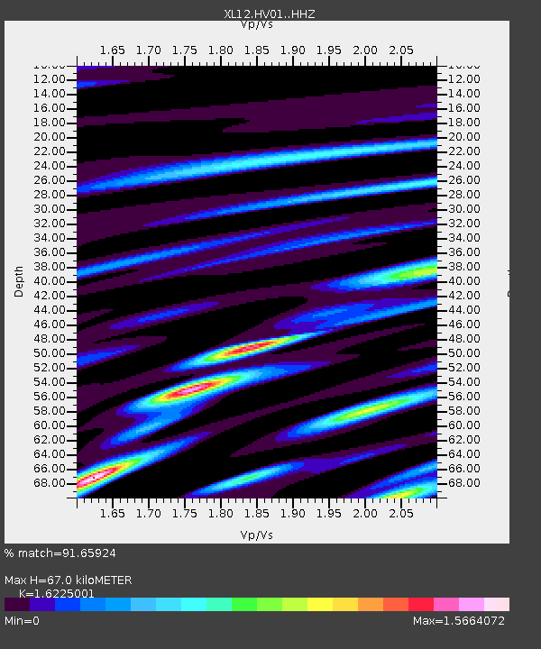
| Estimated Moho Depth: |
67.0 km |
| Estimated Crust Vp/Vs: |
1.62 |
| Assumed Crust Vp: |
6.622 km/s |
| Estimated Crust Vs: |
4.081 km/s |
| Estimated Crust Poisson's Ratio: |
0.19 |
|
| Radial Match: |
91.65924 % |
| Radial Bump: |
400 |
| Transverse Match: |
78.55053 % |
| Transverse Bump: |
400 |
| SOD ConfigId: |
7422571 |
| Insert Time: |
2019-04-21 17:21:00.443 +0000 |
| GWidth: |
2.5 |
| Max Bumps: |
400 |
| Tol: |
0.001 |
|

Signal To Noise
| Channel | StoN | STA | LTA |
| XL:HV01: :HHZ:20160111T16:46:48.499993Z | 41.23876 | 2.6635728E-6 | 6.458906E-8 |
| XL:HV01: :HHN:20160111T16:46:48.499993Z | 17.89954 | 1.0115554E-6 | 5.6512928E-8 |
| XL:HV01: :HHE:20160111T16:46:48.499993Z | 9.75272 | 8.0732156E-7 | 8.2779124E-8 |
| Arrivals |
| Ps | 6.7 SECOND |
| PpPs | 25 SECOND |
| PsPs/PpSs | 32 SECOND |


