You are here: Home > Network List > XL12 - Hangay Dome, Mongolia Stations List
> Station HV02 HV02 > Earthquake Result Viewer
HV02 HV02 - Earthquake Result Viewer
| Earthquake location: |
Talaud Islands, Indonesia |
| Earthquake latitude/longitude: |
3.9/126.9 |
| Earthquake time(UTC): |
2016/01/11 (011) 16:38:07 GMT |
| Earthquake Depth: |
21 km |
| Earthquake Magnitude: |
6.5 MWW, 6.4 MWB, 6.9 MI |
| Earthquake Catalog/Contributor: |
NEIC PDE/NEIC COMCAT |
|
| Network: |
XL Hangay Dome, Mongolia |
| Station: |
HV02 HV02 |
| Lat/Lon: |
51.15 N/99.35 E |
| Elevation: |
1546 m |
|
| Distance: |
52.5 deg |
| Az: |
338.467 deg |
| Baz: |
144.451 deg |
| Ray Param: |
0.066721216 |
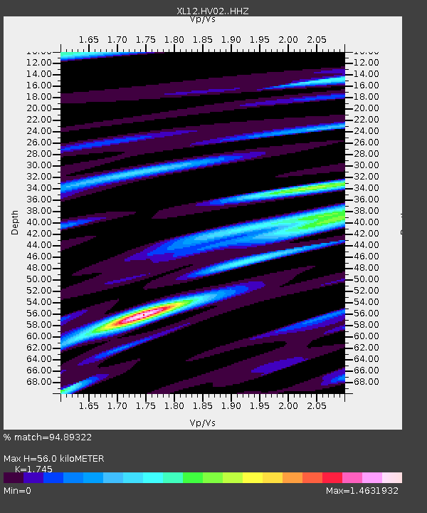
| Estimated Moho Depth: |
56.0 km |
| Estimated Crust Vp/Vs: |
1.75 |
| Assumed Crust Vp: |
6.622 km/s |
| Estimated Crust Vs: |
3.795 km/s |
| Estimated Crust Poisson's Ratio: |
0.26 |
|
| Radial Match: |
94.89322 % |
| Radial Bump: |
400 |
| Transverse Match: |
82.234276 % |
| Transverse Bump: |
400 |
| SOD ConfigId: |
7422571 |
| Insert Time: |
2019-04-21 17:21:02.417 +0000 |
| GWidth: |
2.5 |
| Max Bumps: |
400 |
| Tol: |
0.001 |
|

Signal To Noise
| Channel | StoN | STA | LTA |
| XL:HV02: :HHZ:20160111T16:46:46.968987Z | 45.961746 | 2.6852613E-6 | 5.8423833E-8 |
| XL:HV02: :HHN:20160111T16:46:46.968987Z | 15.53208 | 1.1164384E-6 | 7.187952E-8 |
| XL:HV02: :HHE:20160111T16:46:46.968987Z | 12.101916 | 8.320386E-7 | 6.875263E-8 |
| Arrivals |
| Ps | 6.7 SECOND |
| PpPs | 22 SECOND |
| PsPs/PpSs | 29 SECOND |


