You are here: Home > Network List > YT07 - POLENET Stations List
> Station SURP SURP > Earthquake Result Viewer
SURP SURP - Earthquake Result Viewer
| Earthquake location: |
Talaud Islands, Indonesia |
| Earthquake latitude/longitude: |
3.9/126.9 |
| Earthquake time(UTC): |
2016/01/11 (011) 16:38:07 GMT |
| Earthquake Depth: |
21 km |
| Earthquake Magnitude: |
6.5 MWW, 6.4 MWB, 6.9 MI |
| Earthquake Catalog/Contributor: |
NEIC PDE/NEIC COMCAT |
|
| Network: |
YT POLENET |
| Station: |
SURP SURP |
| Lat/Lon: |
84.72 S/171.20 W |
| Elevation: |
407 m |
|
| Distance: |
91.3 deg |
| Az: |
175.31 deg |
| Baz: |
298.28 deg |
| Ray Param: |
0.04160822 |
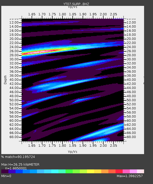
| Estimated Moho Depth: |
26.25 km |
| Estimated Crust Vp/Vs: |
1.69 |
| Assumed Crust Vp: |
6.245 km/s |
| Estimated Crust Vs: |
3.706 km/s |
| Estimated Crust Poisson's Ratio: |
0.23 |
|
| Radial Match: |
90.195724 % |
| Radial Bump: |
400 |
| Transverse Match: |
88.636986 % |
| Transverse Bump: |
400 |
| SOD ConfigId: |
7422571 |
| Insert Time: |
2019-04-21 17:21:49.036 +0000 |
| GWidth: |
2.5 |
| Max Bumps: |
400 |
| Tol: |
0.001 |
|

Signal To Noise
| Channel | StoN | STA | LTA |
| YT:SURP: :BHZ:20160111T16:50:39.723992Z | 4.392283 | 7.8706273E-7 | 1.7919217E-7 |
| YT:SURP: :BHN:20160111T16:50:39.723992Z | 2.6099606 | 2.0092551E-7 | 7.6984115E-8 |
| YT:SURP: :BHE:20160111T16:50:39.723992Z | 1.5435953 | 1.6128773E-7 | 1.0448835E-7 |
| Arrivals |
| Ps | 2.9 SECOND |
| PpPs | 11 SECOND |
| PsPs/PpSs | 14 SECOND |


