You are here: Home > Network List > CN - Canadian National Seismograph Network Stations List
> Station INK INUVIK, NT > Earthquake Result Viewer
INK INUVIK, NT - Earthquake Result Viewer
*The percent match for this event was below the threshold and hence no stack was calculated.
| Earthquake location: |
Hokkaido, Japan Region |
| Earthquake latitude/longitude: |
44.5/141.1 |
| Earthquake time(UTC): |
2016/01/11 (011) 17:08:03 GMT |
| Earthquake Depth: |
240 km |
| Earthquake Magnitude: |
6.2 MWW |
| Earthquake Catalog/Contributor: |
NEIC PDE/NEIC COMCAT |
|
| Network: |
CN Canadian National Seismograph Network |
| Station: |
INK INUVIK, NT |
| Lat/Lon: |
68.31 N/133.53 W |
| Elevation: |
44 m |
|
| Distance: |
48.0 deg |
| Az: |
29.923 deg |
| Baz: |
286.115 deg |
| Ray Param: |
$rayparam |
*The percent match for this event was below the threshold and hence was not used in the summary stack. |
|
| Radial Match: |
66.98372 % |
| Radial Bump: |
362 |
| Transverse Match: |
74.11807 % |
| Transverse Bump: |
400 |
| SOD ConfigId: |
7422571 |
| Insert Time: |
2019-04-21 17:25:40.958 +0000 |
| GWidth: |
2.5 |
| Max Bumps: |
400 |
| Tol: |
0.001 |
|
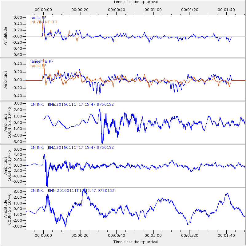
Signal To Noise
| Channel | StoN | STA | LTA |
| CN:INK: :BHZ:20160111T17:15:47.975015Z | 5.652785 | 2.8605134E-6 | 5.0603614E-7 |
| CN:INK: :BHN:20160111T17:15:47.975015Z | 1.5547365 | 9.775423E-7 | 6.2875114E-7 |
| CN:INK: :BHE:20160111T17:15:47.975015Z | 2.5960262 | 1.4061669E-6 | 5.4166134E-7 |
| Arrivals |
| Ps | |
| PpPs | |
| PsPs/PpSs | |


