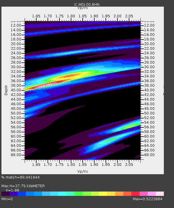
MDJ Mudanjiang, Heilongjiang Province, China - Earthquake Result Viewer
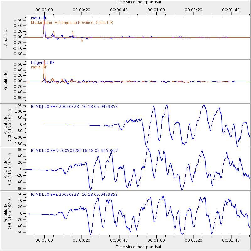
Earthquake location: Northern Sumatra, Indonesia
Earthquake latitude/longitude: 2.1/97.1
Earthquake time(UTC): 2005/03/28 (087) 16:09:36 GMT
Earthquake Depth: 30 km
Earthquake Magnitude: 7.2 MB, 8.4 MS, 8.7 MW, 8.1 MW
Earthquake Catalog/Contributor: WHDF/NEIC
Network: IC New China Digital Seismograph Network
Station: MDJ Mudanjiang, Heilongjiang Province, China
Lat/Lon: 44.62 N/129.59 E
Elevation: 250 m
Distance: 51.1 deg
Az: 29.507 deg
Baz: 223.567 deg
Ray Param: 0.06754532
Estimated Moho Depth: 37.75 km
Estimated Crust Vp/Vs: 1.69
Assumed Crust Vp: 6.459 km/s
Estimated Crust Vs: 3.822 km/s
Estimated Crust Poisson's Ratio: 0.23
Radial Match: 98.841644 %
Radial Bump: 158
Transverse Match: 89.48329 %
Transverse Bump: 400
SOD ConfigId: 2459
Insert Time: 2010-03-04 23:07:52.719 +0000
GWidth: 2.5
Max Bumps: 400
Tol: 0.001

Signal To Noise

ChannelStoNSTALTA
IC:MDJ:00:BHN:20050328T16:18:05.945985Z5.83131842.116242E-63.629097E-7
IC:MDJ:00:BHE:20050328T16:18:05.945985Z4.811372.1525657E-64.4739141E-7
IC:MDJ:00:BHZ:20050328T16:18:05.945985Z4.26593885.089166E-61.1929767E-6
Arrivals
Ps4.3 SECOND
PpPs15 SECOND
PsPs/PpSs19 SECOND