You are here: Home > Network List > TA - USArray Transportable Network (new EarthScope stations) Stations List
> Station A36M Sachs Harbour, NT, CAN > Earthquake Result Viewer
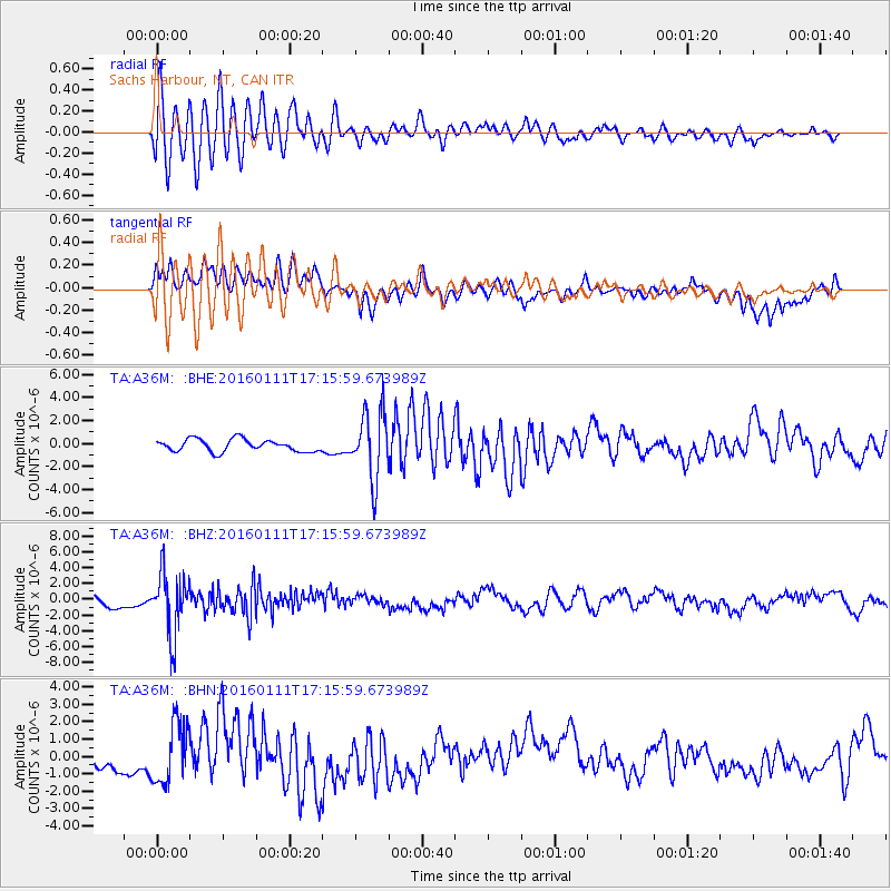
A36M Sachs Harbour, NT, CAN - Earthquake Result Viewer
*The percent match for this event was below the threshold and hence no stack was calculated.
| Earthquake location: |
Hokkaido, Japan Region |
| Earthquake latitude/longitude: |
44.5/141.1 |
| Earthquake time(UTC): |
2016/01/11 (011) 17:08:03 GMT |
| Earthquake Depth: |
240 km |
| Earthquake Magnitude: |
6.2 MWW |
| Earthquake Catalog/Contributor: |
NEIC PDE/NEIC COMCAT |
|
| Network: |
TA USArray Transportable Network (new EarthScope stations) |
| Station: |
A36M Sachs Harbour, NT, CAN |
| Lat/Lon: |
71.99 N/125.25 W |
| Elevation: |
32 m |
|
| Distance: |
49.5 deg |
| Az: |
24.089 deg |
| Baz: |
290.052 deg |
| Ray Param: |
$rayparam |
*The percent match for this event was below the threshold and hence was not used in the summary stack. |
|
| Radial Match: |
72.47633 % |
| Radial Bump: |
400 |
| Transverse Match: |
61.164722 % |
| Transverse Bump: |
400 |
| SOD ConfigId: |
7422571 |
| Insert Time: |
2019-04-21 17:30:43.248 +0000 |
| GWidth: |
2.5 |
| Max Bumps: |
400 |
| Tol: |
0.001 |
|
Signal To Noise
| Channel | StoN | STA | LTA |
| TA:A36M: :BHZ:20160111T17:15:59.673989Z | 6.6720405 | 3.9074002E-6 | 5.8563796E-7 |
| TA:A36M: :BHN:20160111T17:15:59.673989Z | 1.6775101 | 1.7528184E-6 | 1.0448929E-6 |
| TA:A36M: :BHE:20160111T17:15:59.673989Z | 5.508333 | 2.9074783E-6 | 5.278327E-7 |
| Arrivals |
| Ps | |
| PpPs | |
| PsPs/PpSs | |


