You are here: Home > Network List > TA - USArray Transportable Network (new EarthScope stations) Stations List
> Station I23K Minto, Yukon-Koyukuk, AK, USA > Earthquake Result Viewer
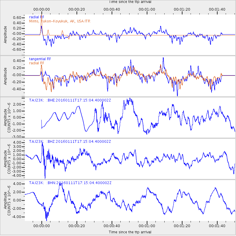
I23K Minto, Yukon-Koyukuk, AK, USA - Earthquake Result Viewer
*The percent match for this event was below the threshold and hence no stack was calculated.
| Earthquake location: |
Hokkaido, Japan Region |
| Earthquake latitude/longitude: |
44.5/141.1 |
| Earthquake time(UTC): |
2016/01/11 (011) 17:08:03 GMT |
| Earthquake Depth: |
240 km |
| Earthquake Magnitude: |
6.2 MWW |
| Earthquake Catalog/Contributor: |
NEIC PDE/NEIC COMCAT |
|
| Network: |
TA USArray Transportable Network (new EarthScope stations) |
| Station: |
I23K Minto, Yukon-Koyukuk, AK, USA |
| Lat/Lon: |
65.15 N/149.36 W |
| Elevation: |
149 m |
|
| Distance: |
42.4 deg |
| Az: |
35.956 deg |
| Baz: |
275.822 deg |
| Ray Param: |
$rayparam |
*The percent match for this event was below the threshold and hence was not used in the summary stack. |
|
| Radial Match: |
66.434845 % |
| Radial Bump: |
400 |
| Transverse Match: |
72.19854 % |
| Transverse Bump: |
400 |
| SOD ConfigId: |
7422571 |
| Insert Time: |
2019-04-21 17:30:56.237 +0000 |
| GWidth: |
2.5 |
| Max Bumps: |
400 |
| Tol: |
0.001 |
|
Signal To Noise
| Channel | StoN | STA | LTA |
| TA:I23K: :BHZ:20160111T17:15:04.400002Z | 3.9419925 | 1.9786514E-6 | 5.01942E-7 |
| TA:I23K: :BHN:20160111T17:15:04.400002Z | 1.0064151 | 2.4956007E-6 | 2.4796932E-6 |
| TA:I23K: :BHE:20160111T17:15:04.400002Z | 1.4365606 | 1.2357481E-6 | 8.60213E-7 |
| Arrivals |
| Ps | |
| PpPs | |
| PsPs/PpSs | |


