You are here: Home > Network List > TA - USArray Transportable Network (new EarthScope stations) Stations List
> Station O03E Paynes Creek, CA, USA > Earthquake Result Viewer
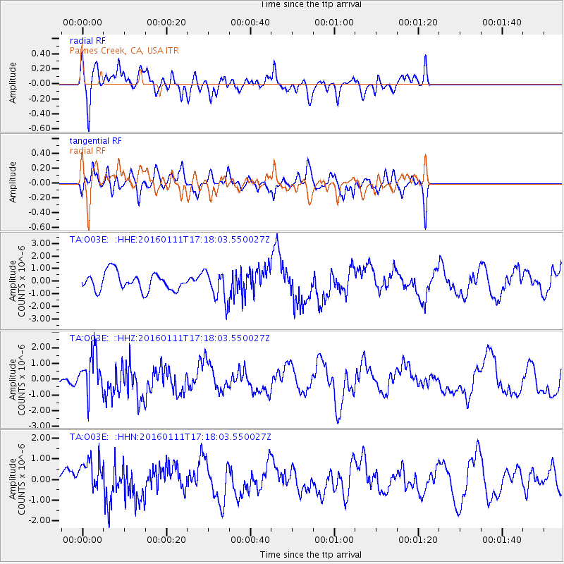
O03E Paynes Creek, CA, USA - Earthquake Result Viewer
*The percent match for this event was below the threshold and hence no stack was calculated.
| Earthquake location: |
Hokkaido, Japan Region |
| Earthquake latitude/longitude: |
44.5/141.1 |
| Earthquake time(UTC): |
2016/01/11 (011) 17:08:03 GMT |
| Earthquake Depth: |
240 km |
| Earthquake Magnitude: |
6.2 MWW |
| Earthquake Catalog/Contributor: |
NEIC PDE/NEIC COMCAT |
|
| Network: |
TA USArray Transportable Network (new EarthScope stations) |
| Station: |
O03E Paynes Creek, CA, USA |
| Lat/Lon: |
40.29 N/121.80 W |
| Elevation: |
967 m |
|
| Distance: |
67.6 deg |
| Az: |
55.202 deg |
| Baz: |
309.759 deg |
| Ray Param: |
$rayparam |
*The percent match for this event was below the threshold and hence was not used in the summary stack. |
|
| Radial Match: |
56.707012 % |
| Radial Bump: |
400 |
| Transverse Match: |
76.71181 % |
| Transverse Bump: |
400 |
| SOD ConfigId: |
7422571 |
| Insert Time: |
2019-04-21 17:31:15.786 +0000 |
| GWidth: |
2.5 |
| Max Bumps: |
400 |
| Tol: |
0.001 |
|
Signal To Noise
| Channel | StoN | STA | LTA |
| TA:O03E: :HHZ:20160111T17:18:03.550027Z | 2.8895264 | 1.2880511E-6 | 4.4576547E-7 |
| TA:O03E: :HHN:20160111T17:18:03.550027Z | 1.0230136 | 8.014096E-7 | 7.833812E-7 |
| TA:O03E: :HHE:20160111T17:18:03.550027Z | 1.6662803 | 1.1598654E-6 | 6.9608063E-7 |
| Arrivals |
| Ps | |
| PpPs | |
| PsPs/PpSs | |


