You are here: Home > Network List > TA - USArray Transportable Network (new EarthScope stations) Stations List
> Station TUL1 Leonard, OK, USA > Earthquake Result Viewer
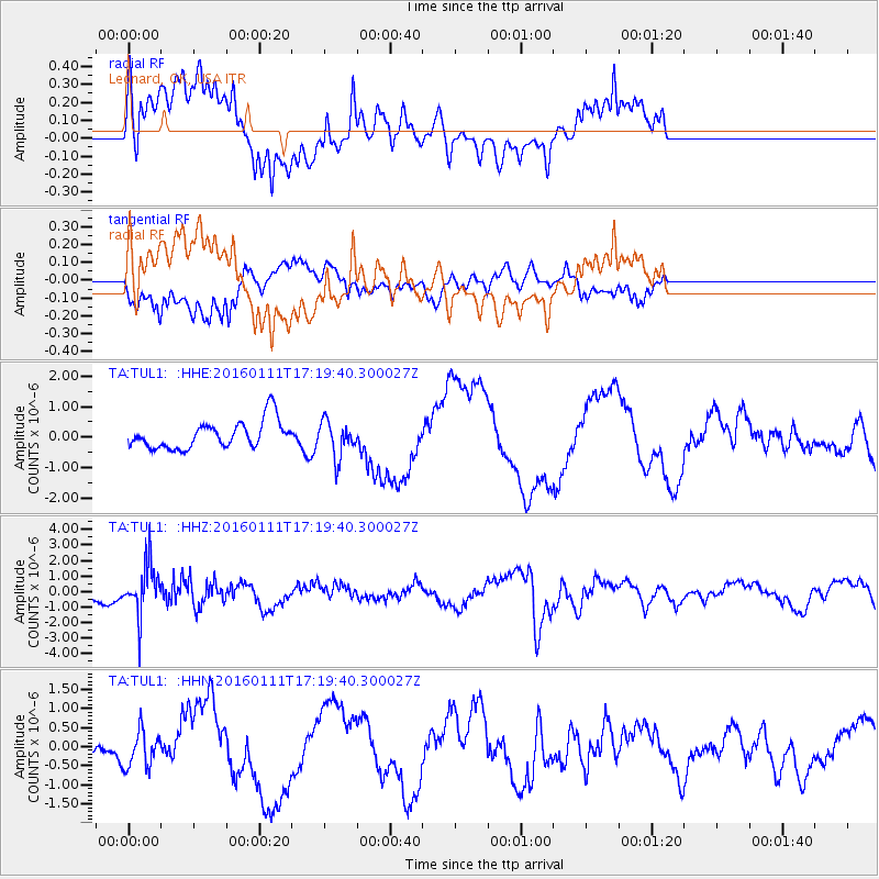
TUL1 Leonard, OK, USA - Earthquake Result Viewer
*The percent match for this event was below the threshold and hence no stack was calculated.
| Earthquake location: |
Hokkaido, Japan Region |
| Earthquake latitude/longitude: |
44.5/141.1 |
| Earthquake time(UTC): |
2016/01/11 (011) 17:08:03 GMT |
| Earthquake Depth: |
240 km |
| Earthquake Magnitude: |
6.2 MWW |
| Earthquake Catalog/Contributor: |
NEIC PDE/NEIC COMCAT |
|
| Network: |
TA USArray Transportable Network (new EarthScope stations) |
| Station: |
TUL1 Leonard, OK, USA |
| Lat/Lon: |
35.91 N/95.79 W |
| Elevation: |
256 m |
|
| Distance: |
84.8 deg |
| Az: |
43.046 deg |
| Baz: |
322.983 deg |
| Ray Param: |
$rayparam |
*The percent match for this event was below the threshold and hence was not used in the summary stack. |
|
| Radial Match: |
57.478012 % |
| Radial Bump: |
400 |
| Transverse Match: |
59.70755 % |
| Transverse Bump: |
400 |
| SOD ConfigId: |
7422571 |
| Insert Time: |
2019-04-21 17:31:27.718 +0000 |
| GWidth: |
2.5 |
| Max Bumps: |
400 |
| Tol: |
0.001 |
|
Signal To Noise
| Channel | StoN | STA | LTA |
| TA:TUL1: :HHZ:20160111T17:19:40.300027Z | 3.380918 | 1.6145448E-6 | 4.775463E-7 |
| TA:TUL1: :HHN:20160111T17:19:40.300027Z | 1.2057276 | 4.736791E-7 | 3.928575E-7 |
| TA:TUL1: :HHE:20160111T17:19:40.300027Z | 1.2874794 | 5.810409E-7 | 4.513011E-7 |
| Arrivals |
| Ps | |
| PpPs | |
| PsPs/PpSs | |


