You are here: Home > Network List > TA - USArray Transportable Network (new EarthScope stations) Stations List
> Station Z41A Richland Creek Farm, El Dorado, AR, USA > Earthquake Result Viewer
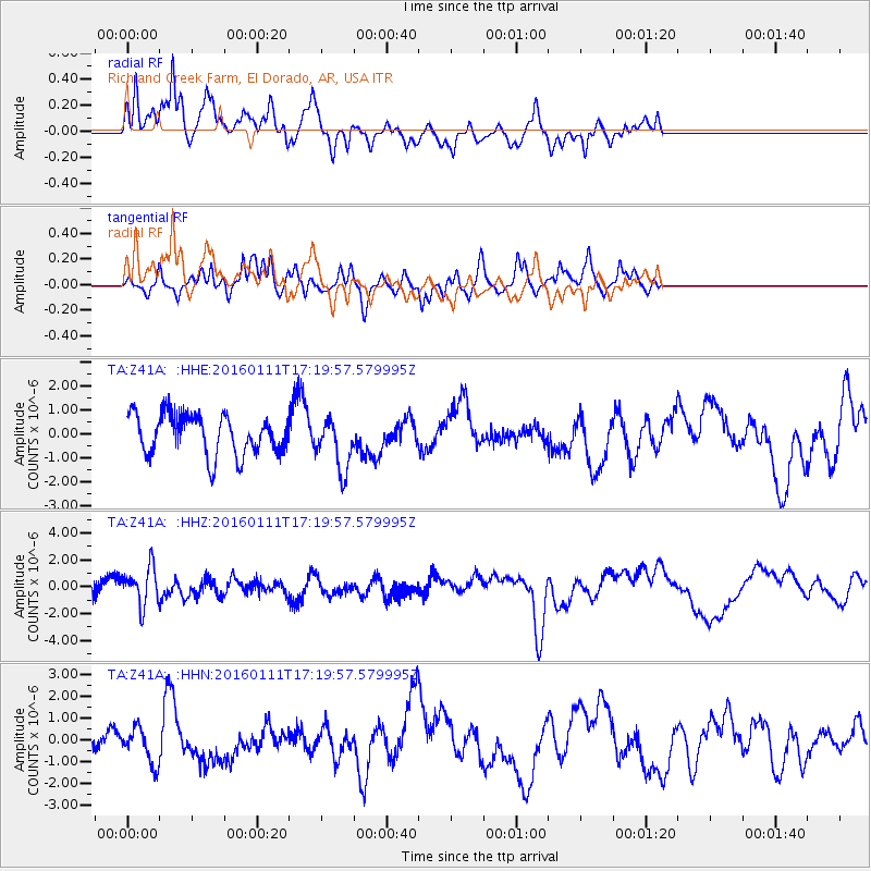
Z41A Richland Creek Farm, El Dorado, AR, USA - Earthquake Result Viewer
*The percent match for this event was below the threshold and hence no stack was calculated.
| Earthquake location: |
Hokkaido, Japan Region |
| Earthquake latitude/longitude: |
44.5/141.1 |
| Earthquake time(UTC): |
2016/01/11 (011) 17:08:03 GMT |
| Earthquake Depth: |
240 km |
| Earthquake Magnitude: |
6.2 MWW |
| Earthquake Catalog/Contributor: |
NEIC PDE/NEIC COMCAT |
|
| Network: |
TA USArray Transportable Network (new EarthScope stations) |
| Station: |
Z41A Richland Creek Farm, El Dorado, AR, USA |
| Lat/Lon: |
33.26 N/92.80 W |
| Elevation: |
62 m |
|
| Distance: |
88.4 deg |
| Az: |
42.616 deg |
| Baz: |
324.647 deg |
| Ray Param: |
$rayparam |
*The percent match for this event was below the threshold and hence was not used in the summary stack. |
|
| Radial Match: |
59.22281 % |
| Radial Bump: |
400 |
| Transverse Match: |
52.24683 % |
| Transverse Bump: |
345 |
| SOD ConfigId: |
7422571 |
| Insert Time: |
2019-04-21 17:31:33.713 +0000 |
| GWidth: |
2.5 |
| Max Bumps: |
400 |
| Tol: |
0.001 |
|
Signal To Noise
| Channel | StoN | STA | LTA |
| TA:Z41A: :HHZ:20160111T17:19:57.579995Z | 2.0694613 | 1.4335043E-6 | 6.9269436E-7 |
| TA:Z41A: :HHN:20160111T17:19:57.579995Z | 1.1017997 | 8.022934E-7 | 7.281663E-7 |
| TA:Z41A: :HHE:20160111T17:19:57.579995Z | 1.3090588 | 1.1011484E-6 | 8.411757E-7 |
| Arrivals |
| Ps | |
| PpPs | |
| PsPs/PpSs | |


