You are here: Home > Network List > US - United States National Seismic Network Stations List
> Station DGMT Dagmar, Montana, USA > Earthquake Result Viewer
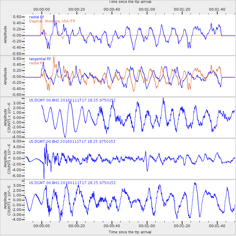
DGMT Dagmar, Montana, USA - Earthquake Result Viewer
*The percent match for this event was below the threshold and hence no stack was calculated.
| Earthquake location: |
Hokkaido, Japan Region |
| Earthquake latitude/longitude: |
44.5/141.1 |
| Earthquake time(UTC): |
2016/01/11 (011) 17:08:03 GMT |
| Earthquake Depth: |
240 km |
| Earthquake Magnitude: |
6.2 MWW |
| Earthquake Catalog/Contributor: |
NEIC PDE/NEIC COMCAT |
|
| Network: |
US United States National Seismic Network |
| Station: |
DGMT Dagmar, Montana, USA |
| Lat/Lon: |
48.47 N/104.20 W |
| Elevation: |
0.0 m |
|
| Distance: |
71.2 deg |
| Az: |
39.674 deg |
| Baz: |
316.616 deg |
| Ray Param: |
$rayparam |
*The percent match for this event was below the threshold and hence was not used in the summary stack. |
|
| Radial Match: |
45.182987 % |
| Radial Bump: |
400 |
| Transverse Match: |
48.571033 % |
| Transverse Bump: |
400 |
| SOD ConfigId: |
7422571 |
| Insert Time: |
2019-04-21 17:31:47.299 +0000 |
| GWidth: |
2.5 |
| Max Bumps: |
400 |
| Tol: |
0.001 |
|
Signal To Noise
| Channel | StoN | STA | LTA |
| US:DGMT:00:BHZ:20160111T17:18:25.975015Z | 4.1448236 | 2.2105467E-6 | 5.3332707E-7 |
| US:DGMT:00:BH1:20160111T17:18:25.975015Z | 1.0241181 | 1.6034826E-6 | 1.5657204E-6 |
| US:DGMT:00:BH2:20160111T17:18:25.975015Z | 0.6734376 | 1.2749018E-6 | 1.8931255E-6 |
| Arrivals |
| Ps | |
| PpPs | |
| PsPs/PpSs | |


